Geolocating the June 22 Hwasong-10 Test: The Kalma Firing Position
A 38 North exclusive with analysis by Joseph S. Bermudez Jr. and Sun Young Ahn.
Summary
While the exact location of the June 22 Hwasong-10 (Musudan) ballistic missile test was not reported by North Korean state media, comparison of the ground photos published and recent commercial satellite imagery indicate that the test took place on the east side of the Kalma International Airport. This airport is in the final stages of being converted from the Wonsan Airbase to modern civilian facility, but also includes a recently constructed firing position for heavy missile transporter-erector-launchers (TELs). It is likely that North Korea will continue to use both this location and its companion facility on the Hodo Peninsula for live-fire artillery, rocket and missile tests, with the Kalma location being used primarily for highly publicized events and the Hodo facility for more routine testing and training.
Kalma Firing Position
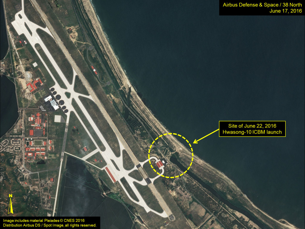
The Kalma International Airport is located on the Kalma Peninsula, east of Wonsan, on North Korea’s east coast. Construction at this airport to convert it from the former Wonsan Airbase into a modern civilian airport began in mid-2014 and is now in its final stages. On the east side of the airport is a small facility that over the past two years has been used for several high-visibility artillery firepower demonstrations and ballistic missile tests.
Figure 1. The Kalma International Airport (formerly Wonsan Airbase).
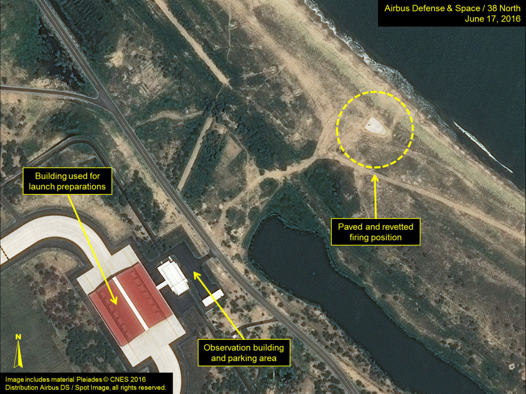
This facility includes an observation building and parking lot adjacent to what appears to be a drive-through maintenance/de-icing building for the airport. This latter building is likely used for pre-launch preparations for rocket and ballistic missile tests. Until recently, firing exercises and missile tests made use of improvised firing positions along the beach. However, during the past two months, a new firing position for heavy missile transporter-erector-launchers (TELs) has been constructed 250 meters east of the observation building. This firing position is roughly “U” shaped, measuring 24-meters-long by 15-meters-wide, is paved and is surrounded by a low sand berm.
Figure 2. New firing positions built at the Kalma International Airport.
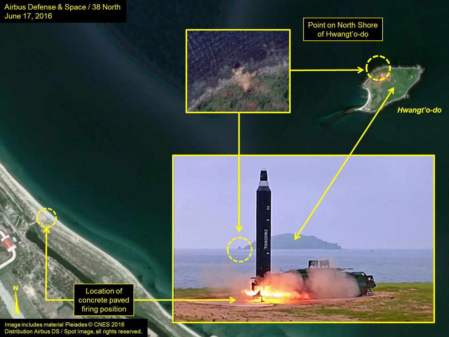
On June 22, 2016, Kim Jong Un “guided the test-fire of surface-to-surface medium long-range strategic ballistic rocket Hwasong-10” (KN-07/Musudan).[1] While Rodong Sinmun and KCTV reporting included a number of images of the event, they did not specify its exact location. However, a comparison of the ground photos with recent commercial satellite imagery from June 17, 2016—just five days before the test—clearly identifies the test as having taken place at the Kalma firing position.
Figure 3. Observation position of the June 22 Hwangsong-10 test.
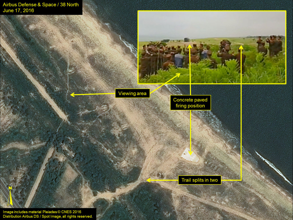
Figure 4. View from the Kalma firing position.
It is likely that North Korea will continue to use both this new location and its companion facility on the Hodo Peninsula (see “Hodo Peninsula Training Area”) for live-fire artillery, rocket and missile tests, with the Kalma location being used primarily for highly publicized events and the Hodo facility for more routine testing and training.
_______________
[1] “Kim Jong Un Guides Test-fire of Hwasong-10,” Rodong Sinmun, June 23, 2016.