North Korea’s Tideland Reclamation Efforts
Overview
Adequate domestic food production is a persistent challenge in North Korea, given its limited arable land. Long-term efforts to increase that capacity through tideland reclamation projects along the country’s west coast began in the 1980s, although suffered serious setbacks in the first decade due to poor engineering and maintenance and natural disasters.
Learning from past mistakes, reclamation efforts under Kim Jong Un have been more successful, with nearly 200 square kilometers now in transition in the North Pyongan and South Hwanghae Provinces since 2010. However, the process of transforming coastal mudflats into fertile farmland is slow and thus, for the near term, has provided minimal relief to the country’s persistent food shortages.
Background
North Korea is located in a temperate climatic zone and experiences a combination of continental and oceanic weather. Much of the country is mountainous, with only about 19.5 percent arable land.[1] The country’s west coast waters are particularly shallow and are significantly impacted by daily tides. The swing between high and low tide oscillates between shallow but navigable waterways, which landlock fishing boats, and commercial shipping traffic for extended periods each day.
The oceanic conditions, inhospitable to sea-going traffic, make an ideal environment for the creation of polders, low-lying tracts of land, enclosed and protected by dikes or levees. Polders are created to claim valuable farmlands from the sea.
The process of reclaiming land from the sea is not a rapid one; it takes many years to naturally fill these areas with the rich soil “runoff” via the country’s inland waterways. While time plays a key role in the creation of polders, the tracts undergo several phases. This creates fertile farmlands as the end game, but as it transforms from saltwater mudflats to arable farmland, the displacement of seawater with fresh water also provides an ideal habitat for fish farming and a prime location for building salterns.
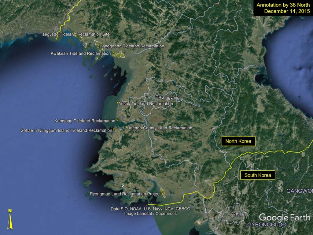
The introduction of polders in North Korea began under Kim Il Sung and continued in earnest under Kim Jong Il. There are approximately 12 major areas where tideland reclamation has been ongoing: the two largest areas are the Taegyedo and Honggondo projects, with the Taegyedo project reportedly reaching the goal of 8,800 hectares of reclaimed land in 2010.[2] The others include: Tasado*, Kwaksan, Ansok*, Kumsong*, Unchon, Sohae-ri-Nunggum Island, Ryongmaedo*, Wol-do*, Ssari-som, and Kangryong.[3] While the extent of the area captured by these efforts is not known, since Kim Jong Il assumed power, a rough estimate gleaned from available commercial imagery, suggests that about 500 square kilometers of land has been reclaimed. A 2012 speech on land management by Kim Jong Un noted that the planned area of tidal reclamation totaled 3,000 square kilometers.[4]
In practice, however, the process of tideland reclamation has been long and fraught with risks. A prime example was in 1997 when a tsunami destroyed the dikes of Taegyedo after a decade and a half of reclamation work. This resulted in a major setback in the North’s land reclamation efforts, as many of the dikes which formed the polders in this area were breached, resulting in the remixing of salt water with the fresh water of the polders, rendering the land unusable for cultivation, at least temporarily.
The government quickly began recovery efforts in Taegyedo and almost immediately claimed successes in rehabilitating its polders, although, much of what was regained can be credited to support given by international aid organizations such as Triangle.[5] Despite these early actions, it was July 2007 before real progress was declared by the government on this project.[6] Since the passing of Kim Jong Il, little has been captured in public statements regarding tideland reclamation. While reclamation efforts have been mentioned in state media and Kim Jong Un’s speeches on occasion, they have not been central to economic plans or risen in prominence. This may be due, in part, to the fact that although dikes can be built rather quickly, filling these areas with soil from runoff cannot be rushed, making timelines for completion difficult to predict.
Figure 1. Overview of west coast tideland projects.
The Building of Polders
The creation of polders is not a quick process. Small, coastal polders can be more readily created, but as is frequently the case in North Korea, programs undertaken by the government tend to be conducted on a grander scale than what is often ideal.
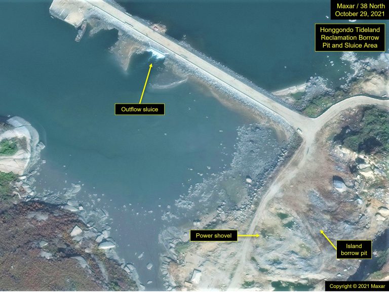
The process of creating polders begins with the building of dikes (also called breakers or levees) which can extend many kilometers offshore. In North Korea, dikes are of earth and rock construction. Power shovels extract those materials from nearby borrow pits or mountainsides located along the coast; in instances where dikes are extended out to offshore islands, the materials are often taken directly from those islands to reduce transport distances. Dump trucks are used in that transport, and finished dikes are topped with both paved and dirt roadways.
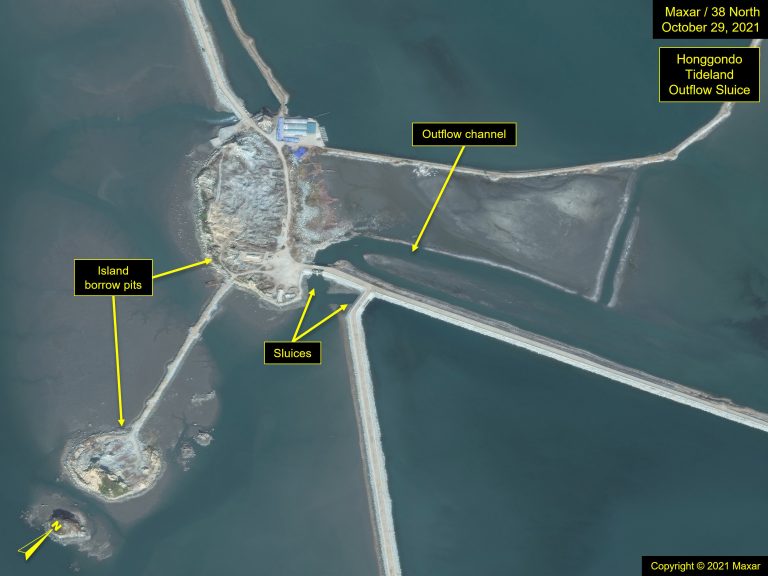
As the dikes are extended into the sea, they, in essence, form causeways that ultimately join with other dikes to create an enclosed hydrologic area. These diked enclosures are fitted with spillways or sluices that allow water to flow out, while preventing seawater from coming in during high-tide, although seawater is allowed to flow in for some of these newly formed reservoirs.
Polders are often created at the mouth of a river, which carries mineral-rich, silty soil. The goal is to fill the large enclosures with the silt and soil carried by the rivers which feed into the polders, gradually displacing salt water with fresh water, and thus cleansing the salinity from the soil. Under normal circumstances, the rivers flow slowly, so when it reaches the newly created polder, the suspended soil separates and gradually fills in the polder, creating a new land mass ready for cultivation. Controlling the flow throughout this process is critical, so a series of canals and/or channels are a common feature.
North Korea generally follows these best practices when constructing its polders. It does appear, based on the quality and pace of polder development after the 1997 tsunami, that quite a bit was learned from the NGOs that provided disaster relief and development assistance.
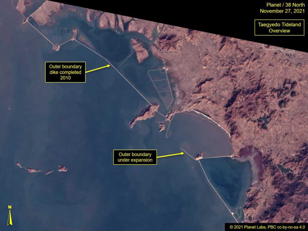
The capture of soil is accomplished in stages. It starts with the creation of the polder’s outer boundary formed by large dikes, capable of holding back the sea during high tides and storms. Smaller dike enclosures are gradually added in a patchwork quilt-like pattern, normally beginning at the shoreline and eventually extending out to the distant, boundary dikes. As each fill with soil, additional enclosures are added. The entire process can take one to two decades to complete depending on the total area of the planned polder, although several hectares of arable land are created within a polder each year. During this process, a canal system is also constructed to support the polder grid, to ensure the land receives adequate irrigation during the dry seasons and excess water can be channeled away as weather conditions dictate. Several factors impact how long it takes to complete any one polder, size being foremost, but extreme weather during a particular year is another key variable. Moreover, the planned size for a polder can change over time. For example, the Taegyedo Tideland was declared “completed” in 2010, however, additional “outer” dikes are presently under construction, indicating that the term “completed” is relative.
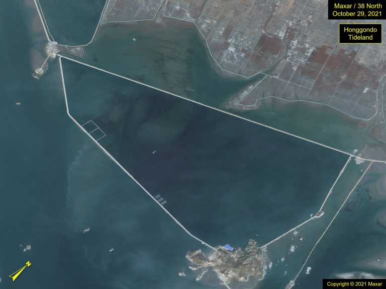
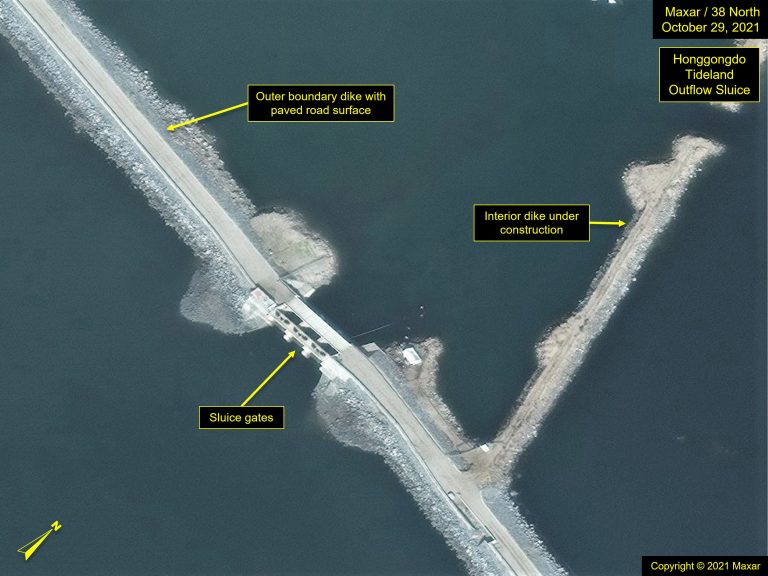
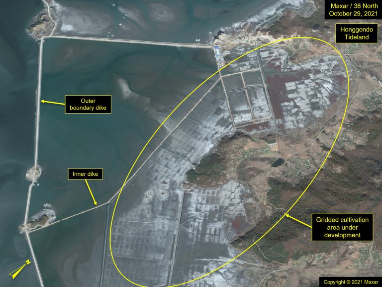
Figures 2-6. Polders and construction at Honggondo Tideland.
Figures 7-8. Taegyedo polder close up of cultivation areas under development, November 2019 and October 2021.
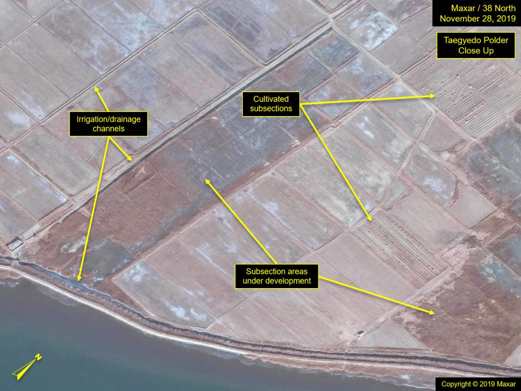
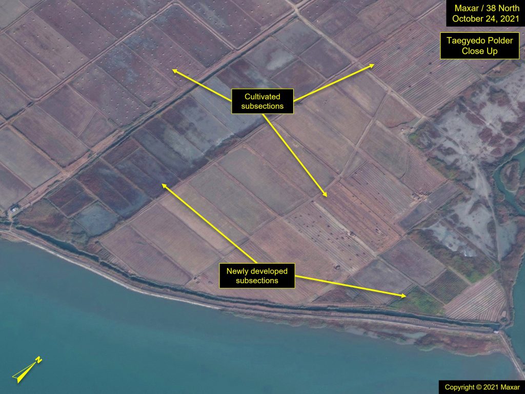
Left: Copyright © 2019, Maxar; Right: Copyright © 2021, Maxar.
Figure 9. Dump trucks transporting dirt at a polder, KCTV.
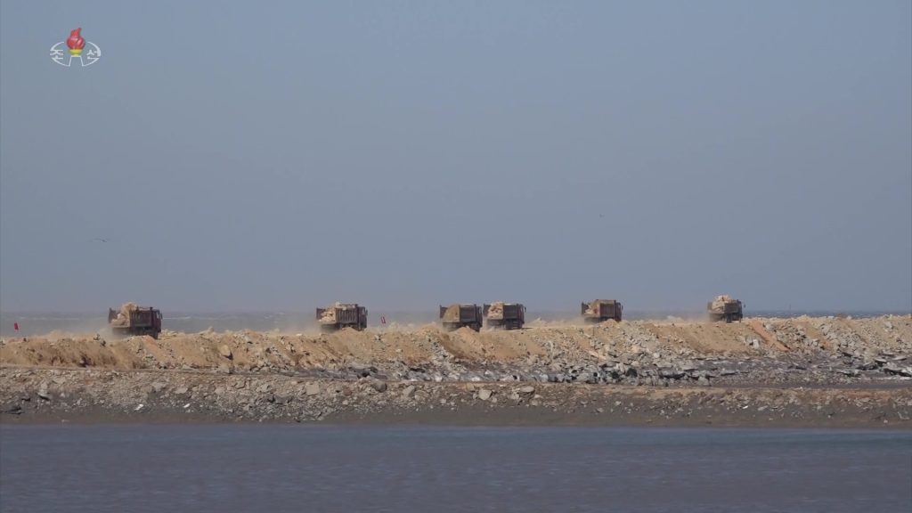
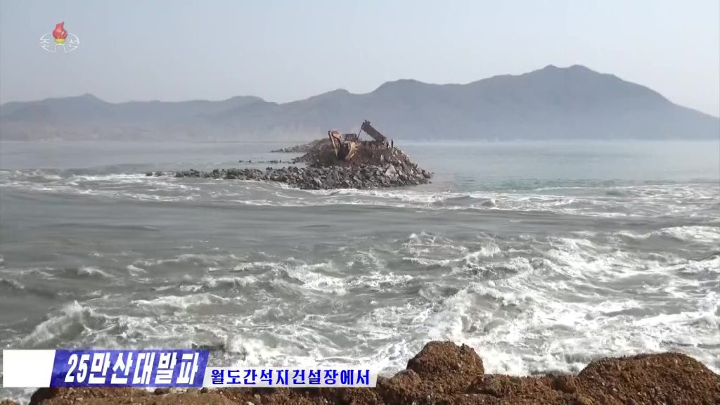
Figure 10. Dike construction at Woldo Tideland, KCTV.
Bridging Activities During the Transition Period
After the dikes are constructed and the tide waters are kept at bay, a new hydrological environment begins to emerge as the trapping of soil runoff begins. This new, albeit temporary environment, allows for other activities to occur, the two principal ones being aquaculture and the building of salterns.
- Aquaculture: Also known as aquafarming, it is the controlled cultivation of aquatic organisms such as fish, crustaceans, mollusks, algae, and other aquatic plants. Commercial satellite imagery provides insights on the flow of water into and around these diked areas; most of the plants and fish are from the sea, as opposed to freshwater, but reporting suggests there is a mix of fresh and saltwater reservoirs.[7]
- Salterns: A saltern is an area or installation for making salt. This includes modern saltworks, as well as waters that usually contain high concentrations of halophilic microorganisms, including algae and bacteria. Salterns usually begin with seawater as the initial source of brine; water is then evaporated, usually over a series of ponds, to the point where sodium chloride and other salts precipitate out, allowing pure salts to be harvested.
Both of these features are common during the long transition period it takes to convert the coastal mudflats into farmland. However, whereas the creation of salterns is likely temporary, an activity undertaken while salts are being removed from the soil, the North Koreans might try to maintain the aquaculture environments even after the transition is complete. This is especially true in the northern provinces, where a series of outer dikes provides a layer of protection to the canals and shoreline polders. Unlike the east coast, where offshore fish cage farms dot protected bays and coves, there are few if any protected water areas naturally suitable for aquaculture outside of the artificial breakers.
Crops of the reclaimed land
Once the reclaimed land is suitable for planting, which could take years to decades depending on the total area and composition of the polder area, rice and corn (maize) become the chief crops accounting for the bulk of harvest.[8] Other plants from grains to soybeans can also be found growing in the rich soil of the polders.
Figure 11. Salterns and aquaculture areas at Kumsong North Central Reclamation Area.
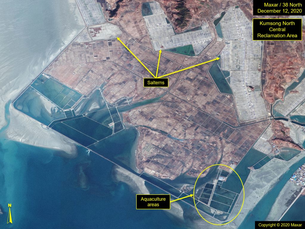
Figure 12. Evaporation ponds at Kumsong saltern.
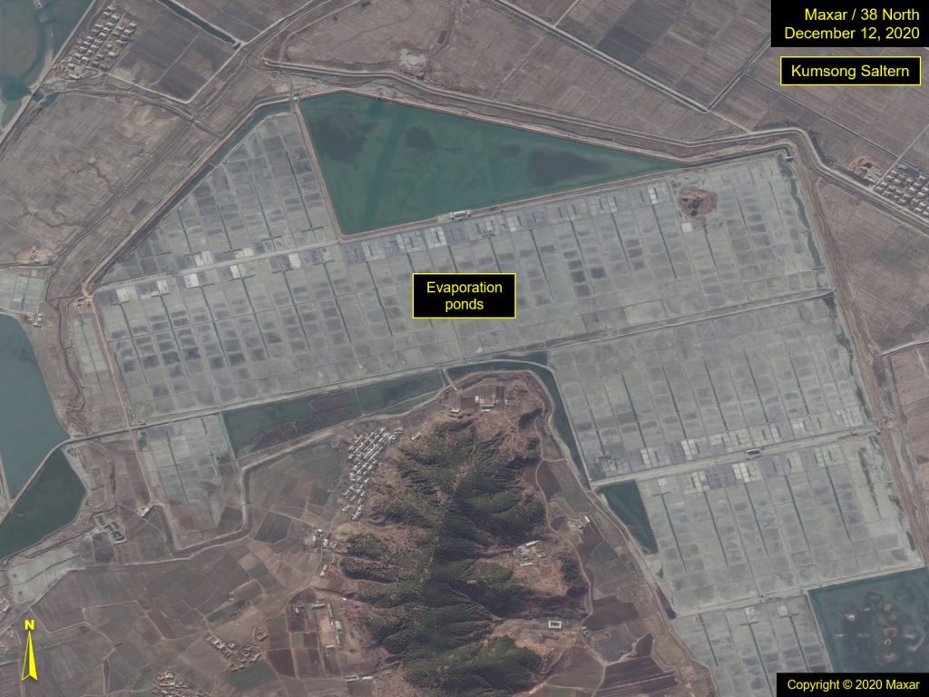
Figure 13. Kim Jong Un visited Kwisong Saltern in May 2016.
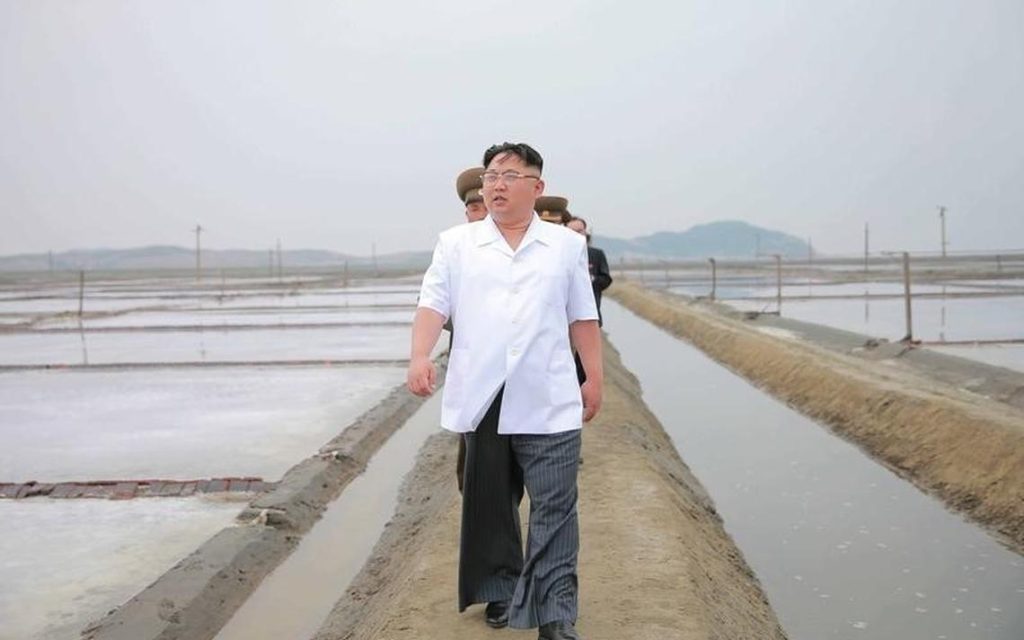
Figure 14. Overview of Kumsong Aqua Plant Farm.
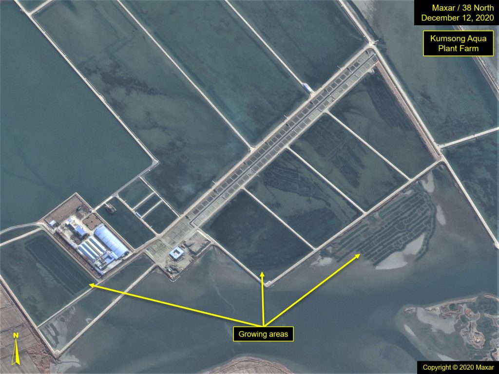
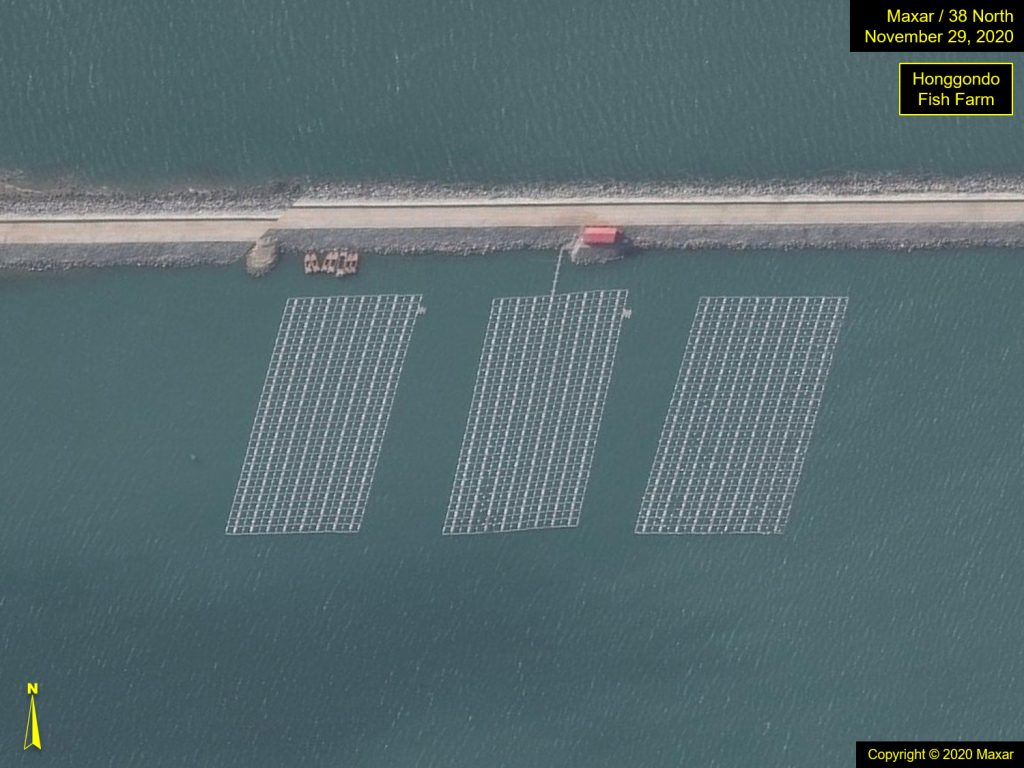
Figure 15. Overview of Honggondo fish farm.
A Closer Inspection of Three Polders
This report examines three of the more actively growing polders; two in North Pyongan province (Taegyedo and Honggondo) and one in South Hwanghae Province (Ryongmaedo). Within these areas, it is estimated that approximately 200 square kilometers have been enclosed by dikes since 2010, all of which will transition into arable land in the next decade or two. [9]
Taegyedo Tideland
The farthest north of the three reclamation areas, Taegyedo Tideland is the oldest and most storied. Construction began in the early 1980s and while the project pressed forward with a degree of intensity under Kim Jong Il, the 1997 tsunami destroyed much of the breakers. This setback was instructive to the North Koreans. With the help of international assistance, they were able to salvage the project, however, work progressed in a more measured fashion and moderate pace afterwards.
The project was technically declared complete in June 2010.[10] By then, rice was being planted in the newly created fields, and completed seawalls allowed for the creation of both saltwater and freshwater reservoirs, creating habitats for fish, shellfish, and lobster farming. Salterns also dotted the landscape. However, work continued on the project well past 2010, with approximately 45 square kilometers added by August 2012, and another 2 square kilometers by June 2013.
Even after 2013, breakers were observed extending into the sea, indicating further additions were planned. Imagery indicates that by 2019, new extensions were evident, and by October 2020 an additional 20 square kilometers had been added. Despite few media mentions, work continues in this area, with nearly another 18 square kilometers added by November 2021.
While these new areas are still in the transitional phase and will take still several years before turning into cultivatable land, the continued build out demonstrates the country’s commitment to tideland reclamation.
Figure 16. Overview of Taegyedo Tideland Reclamation.
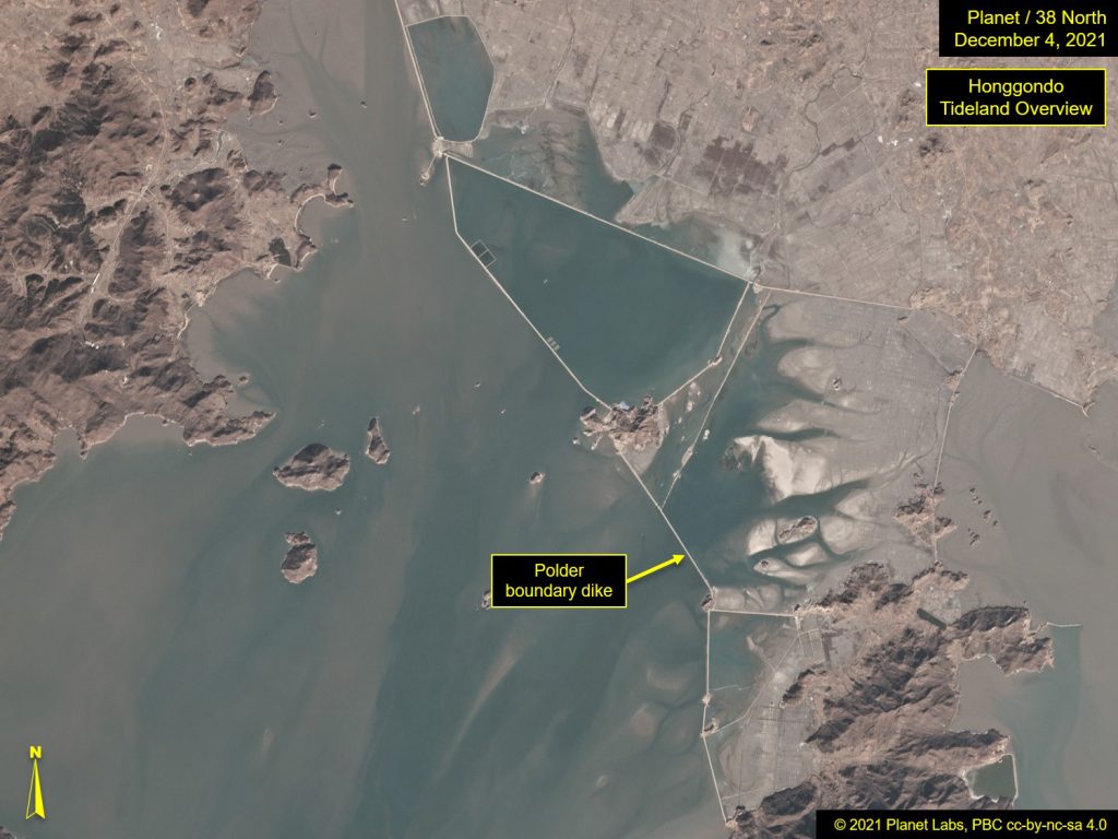
Honggondo Tideland
Located east of the Sohae Satellite Launching Station, Honggondo has seen similar dramatic growth over the past decade. While imagery coverage for this area is sparse, making the development timeline difficult to assess, it appears that efforts on this project began in earnest around 2013. Breakwater construction began by May 2014, and by 2017, North Korea achieved reclaiming an initial approximate of 28 square kilometers. That continued to expand so that by 2018, another 12 square kilometers had been added, and by 2019, a total of approximately 76 square kilometers had been closed off from the tidal sea.
Imagery of Honggondo shows fish and algae farms and the presence of salterns in this area, suggesting it was still in its transitional state and not yet ready to use as farmland.
In May 2021, state media touted the second-phase completion of Honggondo Tideland, stating it was “largest in its scale in history of tideland reclamation” and that this phase was completed in half the anticipated time (four years instead of eight).[11] The site was highlighted again in September for large-scale rice fields, but due to limited recent commercial satellite image coverage, the current status cannot be confirmed.[12]
Figure 17. Overview of Honggondo Tideland.
Ryongmaedo Tideland
Ryongmaedo Tideland, located in South Hwanghae Province is a much smaller project and has a very different structure than previously discussed tideland projects. In the northern areas, small islands dot the coastline, and breakers can be extended from island to island, giving them solid grounding. However, Ryongmaedo does not have this small island composition, and instead, breakers are extended open ended out into the sea (a much riskier venture) making the reclaimed area more fragile overall.
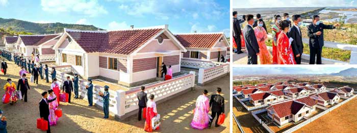
In 2019, a Pyongyang Times article about the three reclamation projects reported that work in all three areas had been “kicked into high gear,” and highlighted the ideal conditions in the Haeju Bay.[13] This project is still active, with an October 28, 2021 Korean Central News Agency (KCNA) report highlighting tens of newlyweds moving into new houses in this area, as they had volunteered to work at the Ryongmaedo tideland construction site, wanting to be a part of the “struggle for enlarging the land of the country.”[14]
Figure 18. Overview of Ryongmaedo Tideland.
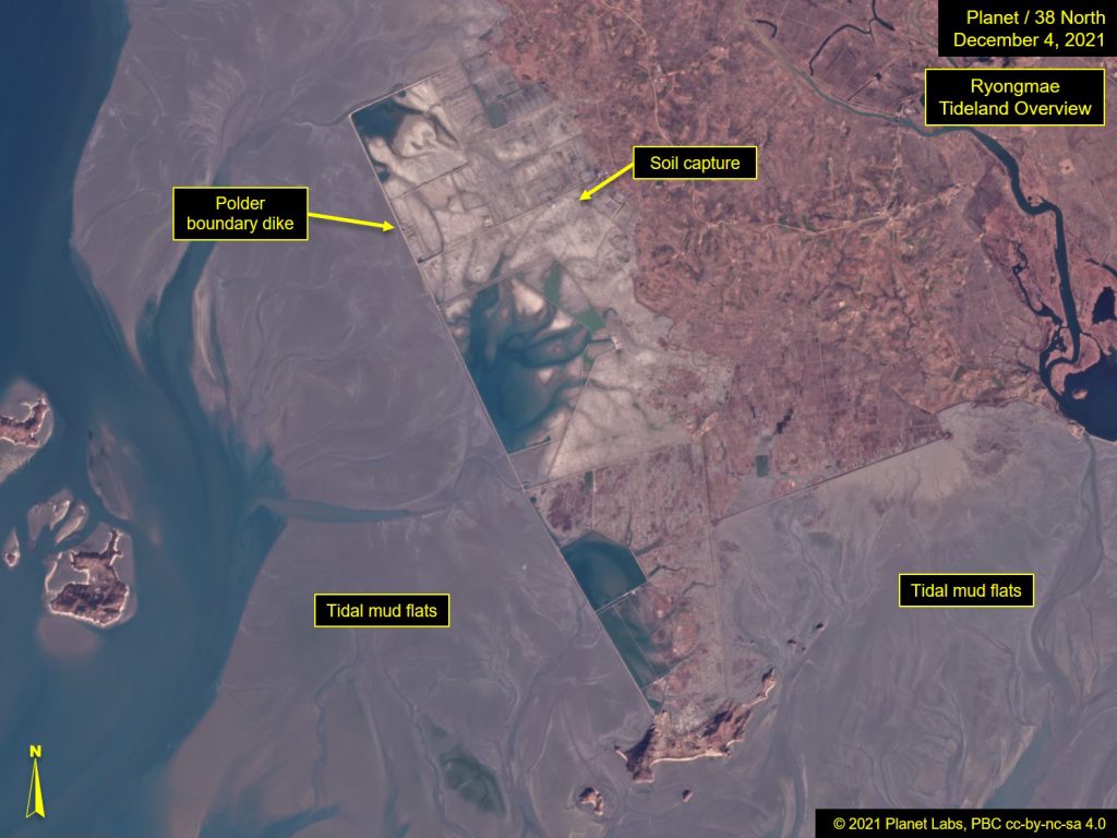
Figure 19. State media coverage of newlyweds arriving in Ryongmaedo.
Conclusion
In the last decade, there has been an uptick in reclamation efforts along the west coast. In three of the key locations, Taegyedo, Honggondo, and Ryongmaedo, almost 200 square kilometers have been secured by dikes since 2010, approximately half of which were secured in the last three years. But the creation of polders and their transformation into arable farmland is a long-term process, spanning years to decades depending on the level of commitment, scale of project area, and the ability to mitigate environmental challenges. Therefore, most of the aforementioned areas remain mud flats or enclosed reservoirs for now, offering little immediate relief to current food shortages. While these transitional areas can be used for aquaculture in the meantime, the scale of their operations is small and thus make only a limited contribution to the country’s greater food needs.
Looking Ahead
The speed at which additional dikes are built and the area they enclose. Signs of greater fish farming.
Things To Watch
- Will North Korea increase its pace of tideland reclamation efforts?
- Will future imagery indicate signs of greater fish farming and other aquaculture projects?
The Stimson Center and the National Geospatial-Intelligence Agency partnership uses unclassified imagery and data to produce new, timely, and accurate reporting on the North Korean economy. For more info, read the Tearline Project Explainer.
To read more, visit NGA’s Tearline article or download the Tearline app from the Apple Store or Google Play.
This content also syndicates to the Office of the Director of National Intelligence’s website intelligence.gov, which is a transparency effort to better explain certain strategic and humanitarian IC missions to the public.
- [1]
United States Central Intelligence Agency, “Korea, North” in The World Factbook 2021, (Washington, DC: Central Intelligence Agency, 2020), https://www.cia.gov/the-world-factbook/countries/korea-north/#geography.
- [2]
Completion Ceremony of Taegyedo Tideland,” Korean Central News Agency (KCNA), June 30, 2010.
- [3]
Those mentioned followed by an asterisk are ones that have appeared in speeches and/or press releases, although save for a couple of articles accompanied by photographs, detail regarding each has been minimal.
- [4]
“Kim Jong Un’s Work on Land Management Published,” KCNA, May 8, 2012. English translation of Kim’s speech, titled, “On Bringing About a Revolutionary Turn in Land Administration in Line with the Requirements of the Building of a Thriving Socialist Country,” was delivered to “leading officials of party and state economic bodies and working people’s organization” on April 27, 2012. Kim identified 300,000 hectares of land were planned for tidal reclamation efforts. English translation of speech available: https://www.nkeconwatch.com/nk-uploads/KJU-land-management-2012.pdf.
- [5]
“DPR Korea OCHA Situation Bulletin Aug/Sep 2004,” ReliefWeb, United Nations Office for the Coordination of Humanitarian Affairs (OCHA), September 30, 2004, https://reliefweb.int/report/democratic-peoples-republic-korea/dpr-korea-ocha-situation-bulletin-augsep-2004.
- [6]
North Korea Newsletter No. 114, July 8, 2010. Also, “KCNA Releases Report on Completion of Taegyedo Tideland” KCNA, June 30, 2010.
- [7]
See: “Land reclamation in the DPRK,” North Korean Economy Watch, August 22, 2009, https://www.nkeconwatch.com/2009/08/22/land-reclamation-in-the-dprk/; and “More DPRK efforts to boost food production,” NK Economy Watch, February 7, 2011, https://www.nkeconwatch.com/2011/02/07/more-dprk-efforts-to-boost-food-production/.
- [8]
USDA Foreign Agriculture Service, Commodity Intelligence Report—North Korea 2021/22 Seasonal Crop Outlook, July 27, 2021.
- [9]
Estimated based on measurements from recent Planet imagery of the added area.
- [10]
“Great Achievements Made in 2010,” KCNA, December 6, 2010.
- [11]
“Report on Completion of Second-Phase Project of Honggondo Tideland and 3rd, 4th District Project of Ryongmaedo Tideland,” KCNA, May 1, 2021.
- [12]
“Honggondo Reclaimed Tideland Turns into Vast Rice Fields,” KCNA, September 6, 2021.
- [13]
Choe Kwang Jin, “Tideland reclamation kicked into high gear” Pyongyang Times, February 5, 2019, http://www.pyongyangtimes.com.kp/?bbs=28997.
- [14]
“New Dwellings Built in Ryongmaedo Tideland,” KCNA, October 28, 2021.