North Korea’s Komdok Mining Region: Empty Promises?
Overview
In 2020, Typhoon Maysak ravaged North Korea’s northeast provinces, devastating large portions of the mineral-rich mining region of Komdok. In the storm’s wake, Kim Jong Un directed a plan to rebuild Komdok and transform it into a “model” mining community. Nearly two years later, the flood-damaged road and railway networks have been restored, and over 2,000 new housing units have been constructed.
Despite those efforts, there is little evidence of actual plans to transform Komdok to “model” status beyond the new housing. Even that is a bit of a façade, as speed has been emphasized over quality, raising concerns about their survivability. Without substantive investments, such as developing better transport networks or improving energy provision, the region will remain underperforming.
Activity
Despite instructions to transform the Komdok mining region into a model mining community, so far efforts have been largely focused on expanding housing and band-aid repairs from the 2020 typhoons. But the terrain and weather patterns of this region make even those efforts seem in vain without greater investment in infrastructure, energy provision and anti-flooding mitigation. Without such efforts, plans for the Komdok region appear little more than empty promises.
Background
North Korea is a mineral-rich country. While coal and iron comprise the largest deposits, the country is believed to have reserves of more than 200 mineral types, including zinc, gold, copper, magnetite, tungsten, graphite, and lead, as well as non-metallic minerals, such as magnesite and limestone. Estimates suggest that the country’s mineral resources are worth trillions of dollars.
The Komdok region is believed to hold the world’s second-largest deposits of magnesite and is rich in lead and zinc, and to a lesser extent, gold and silver, leading some to call this area “Kumgol” (gold valley), “Tonsan” (mountain of money), and “Paekgumsan” (white gold mountain). Located in South Hamgyong Province, approximately 40 kilometers north of the port city of Tanchon and nestled within the Puktae-chon Valley, dozens of mines are arrayed around three major mining complexes: Komdok (Kumdok)/Ryongyang, Taehung, and Tonsan.
Figure 1. Overview of Komdok Mining Region.
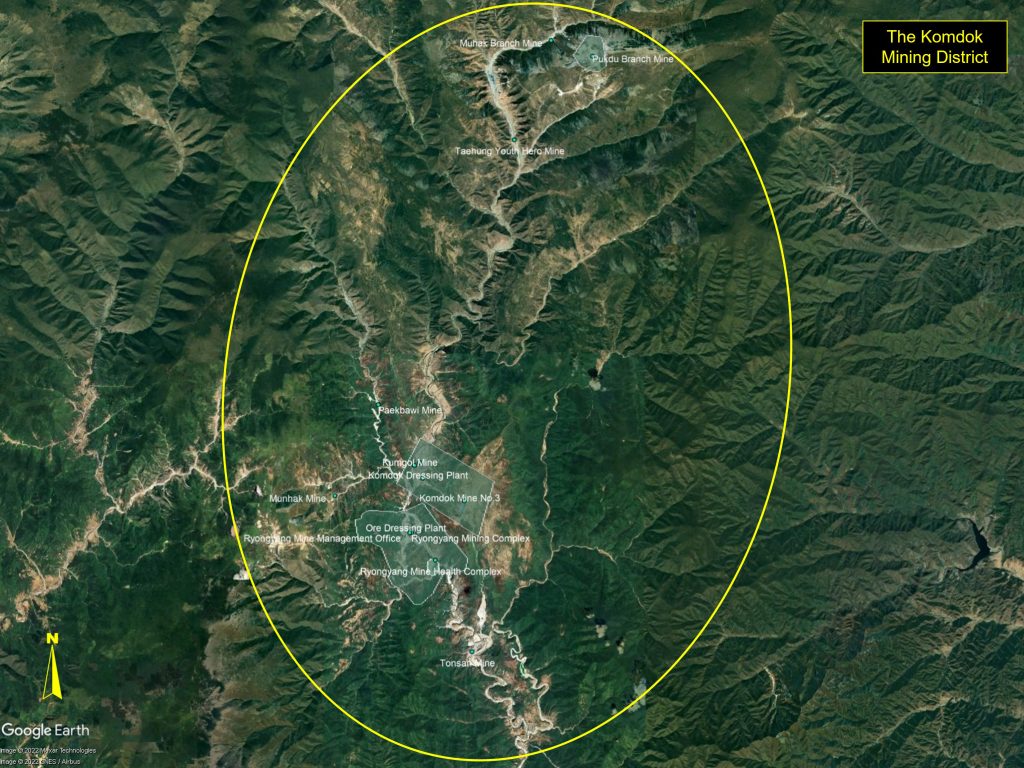
These complexes cover a north-to-south distance of over 30 kilometers along the Puktae River and include the Pukdu and Muhak branch mines, the Taehung Youth Hero Mine, the Paekbawi Mine, the Kumgol Mine, the Komdok mines, the Ryongyang mines, the Tonsan Mine, and a number of smaller mines.
Figure 2. Taehung Mining Area.
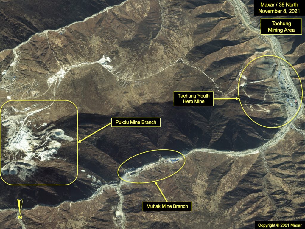
Figure 3. Komdok and Ryongyang Mining Areas.
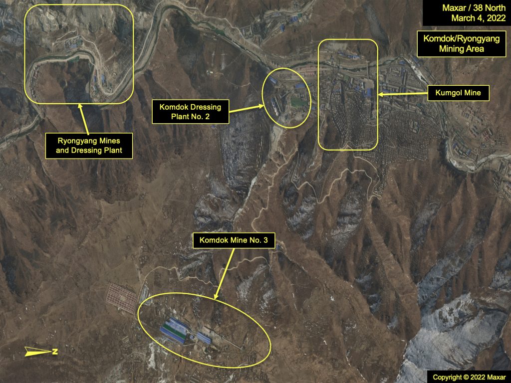
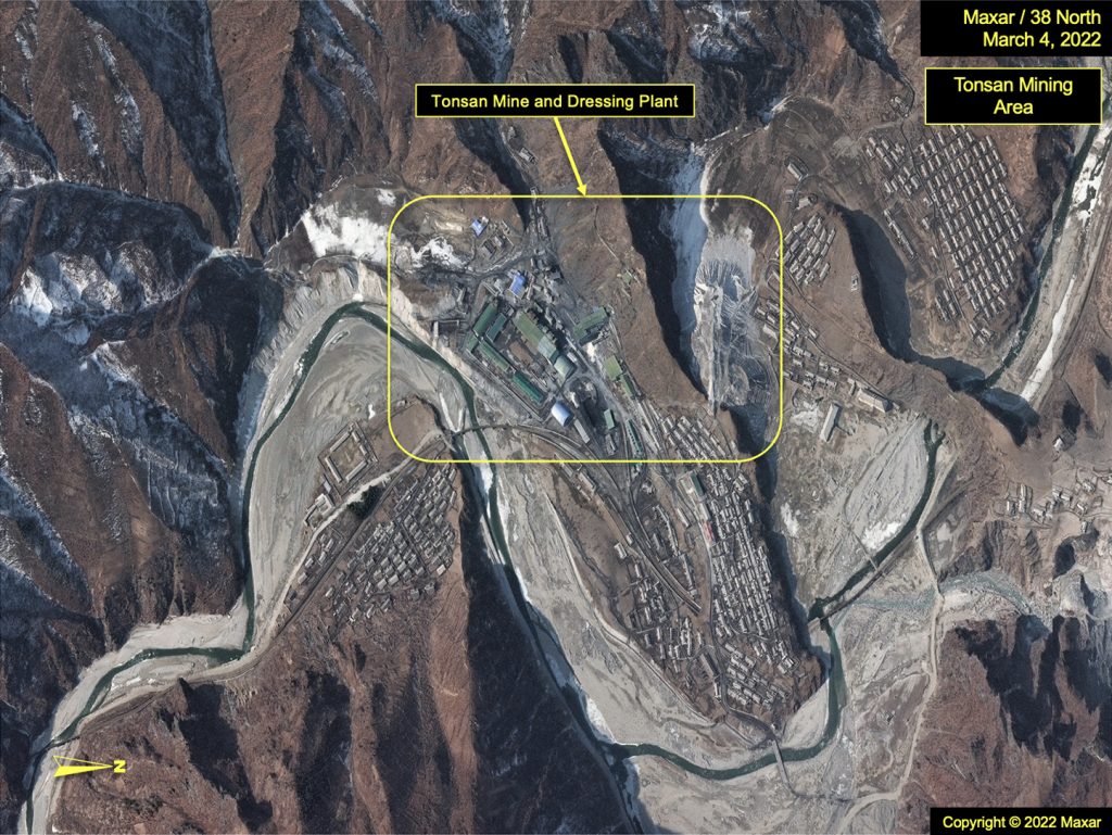
Figure 4. Tonsan Mining Area.
However, the region’s economic potential has largely gone unrealized for several reasons, including historical mismanagement of resources, outdated mining equipment and practices, an arcane and inadequate infrastructure, and seasonal flooding, all of which have hampered production. Moreover, North Korea’s continued pursuit of nuclear weapons has brought about heavy international sanctions on the country’s exports, limiting access to global markets.
While mining has continued, there has been little evidence of efforts to improve the region’s infrastructure or to increase output over the past decade, aside from post-flooding repairs and recovery.
In 2020, North Korea’s economic priorities appeared to shift. The borders had been closed to trade and travelers since January of that year to help prevent a major COVID-19 outbreak inside the country. As such, efforts and resources that had been applied toward the development of tourism and light industry for export were redirected to more domestically focused priorities and projects, such as the still unopened Pyongyang General Hospital and numerous housing projects.
The Komdok region appears to be one of the beneficiaries of this shift. Kim Jong Un visited here for the first time in early September 2020, after Typhoon Maysak ripped through the region. He directed not only its swift recovery but further development into a “model” mining community.
In a series of speeches, he emphasized the importance of Komdok to North Korea’s strategic and economic objectives, citing critical products present within the region necessary to build the country’s infrastructure, meet its growing housing requirements, and provide reliable supplies of food. As such, keeping these mines working was imperative.
In the following weeks and months, repairs were made to the roads and rail servicing the region, and new housing sprang up along the valley (see figures 15, 16, 17). Additional new housing projects were also included as part of the five-year economic plan launched at the Eighth Party Congress in January 2021. But actual investment in the mines themselves and their supporting infrastructure such as new roads or rail lines—efforts to truly improve Komdok—were not evident.
Overview of Major Mining Complexes
About the Mines
There are principally two types of mines in the region: open pit and underground. Open pit mines are surface mines. Typically, when an ore vein is located near the surface, tunnels are not necessary and other surface minerals are merely scraped away and set aside in piles of spoil. The ore is typically loaded onto trucks and hauled to nearby processing plants where further separation and refinement occurs.
Underground mines are, in essence, tunnels bored into underground ore veins. The veins can be thin or thick layers beneath the surface and are reached through either surface entrances or adits located along mountainsides. Depending on the size of the vein, it can be accessed in more than one location, and if an ore layer is particularly thick, tunnels can cross one another, or even pass over or under another. In areas such as on a plateau, vertical shafts may be used to provide access to deeper target ore layers. Once the layer is reached, tunneling commences.
Extracting ores from the mines can be through the use of trucks, ore cars on rails, conveyors, elevators, or a combination of these. Whether a vein is accessed vertically or horizontally, like the open pit mines, a processing plant is normally found nearby. In mountainous terrain, such as the Komdok region, lengthy, covered conveyors are often used to move the ore to the processing plants or to a rail yard for transport out of the region.
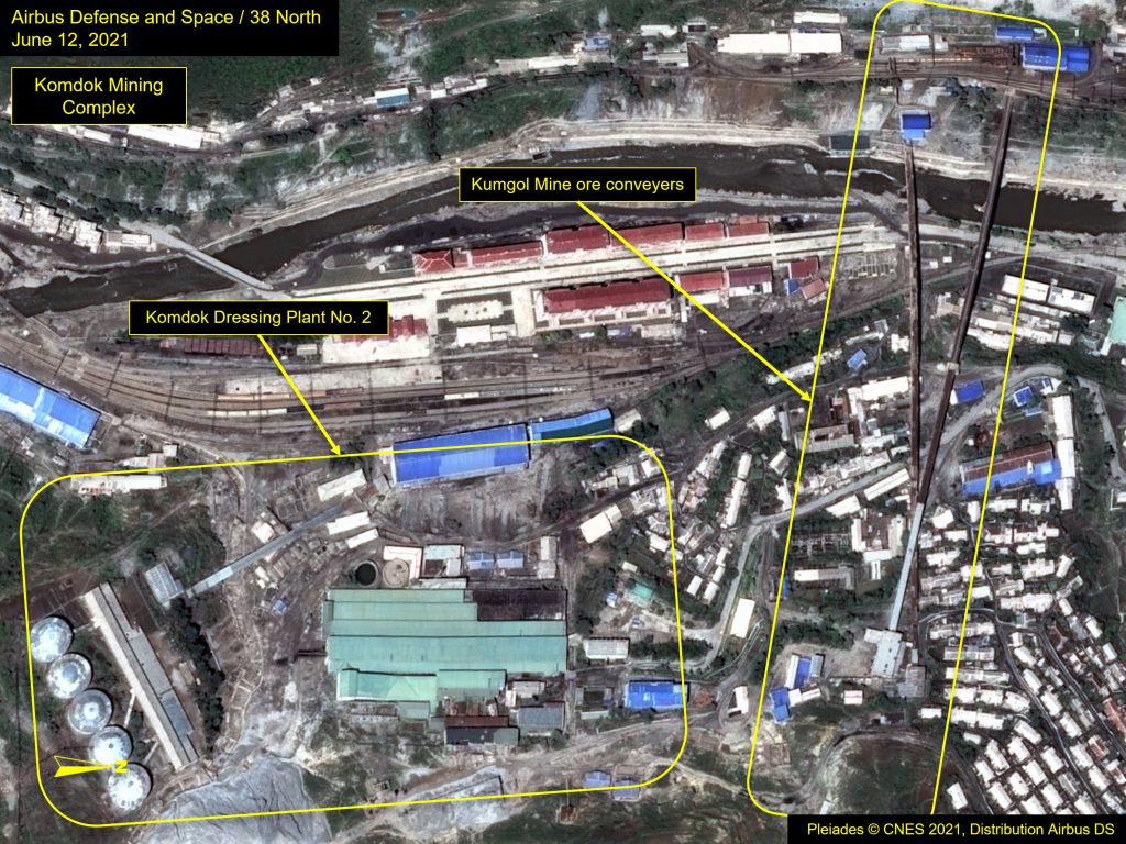
The Komdok Mines
North Korea has the capacity to be one of the leading producers of zinc in the world. Zinc has a wide range of uses. On the industrial side, it is used to galvanize other metals and create alloys such as brass, nickel silver, and aluminum. On the commercial side, zinc oxide is used in a variety of manufactured products such as batteries, pharmaceuticals, plastics, and electrical equipment, making it a valuable commodity.
One of the mines within this complex is located in Kumgol-dong, 50 kilometers north of Tanchon, and has estimated zinc reserves of 266 million tons of ore. It has been in operation since 1932 and is believed to be the largest zinc mine in East Asia. It is operated by the Korea General Zinc Industry Group, and extraction of zinc from raw ore is mainly done by a conventional flotation method conducted at Komdok’s Dressing Plant No. 2. This plant is readily distinguished from other processing plants, by the large hillside flotation tanks, a necessary processing step for certain ores, and in this case, zinc.
Figure 5. Komdok Mining Complex.
The Ryongyang and Taehung Mines
Magnesite is the principal ore extracted from the Ryongyang (figure 6) and Taehung mines. The Ryongyang Mine is the largest in North Korea and one of the largest in the world and is located at Kumgol’s southern edge. The Taehung Youth Hero Mine, located to the north, received particular recognition in 2011 when Kim Jong Il visited and praised its miners for their herculean efforts in exceeding their annual quotas.
Magnesite is found in large quantities in the Tanchon area and has been extracted since 1980. The United States Geological Survey (USGS) estimates the Ryongyang Mine to have a magnesite reserve of 600 metric tons and the Taehung Youth Hero Mine to have a reserve of 600 metric tons. However, production declined sharply in 2017, with the imposition of harsher sanctions in response to North Korea’s ballistic missile and nuclear weapons testing. No real improvements have been made to either the political climate or physical mining infrastructure since then that would change the production outlook for these two mines in a more positive direction.
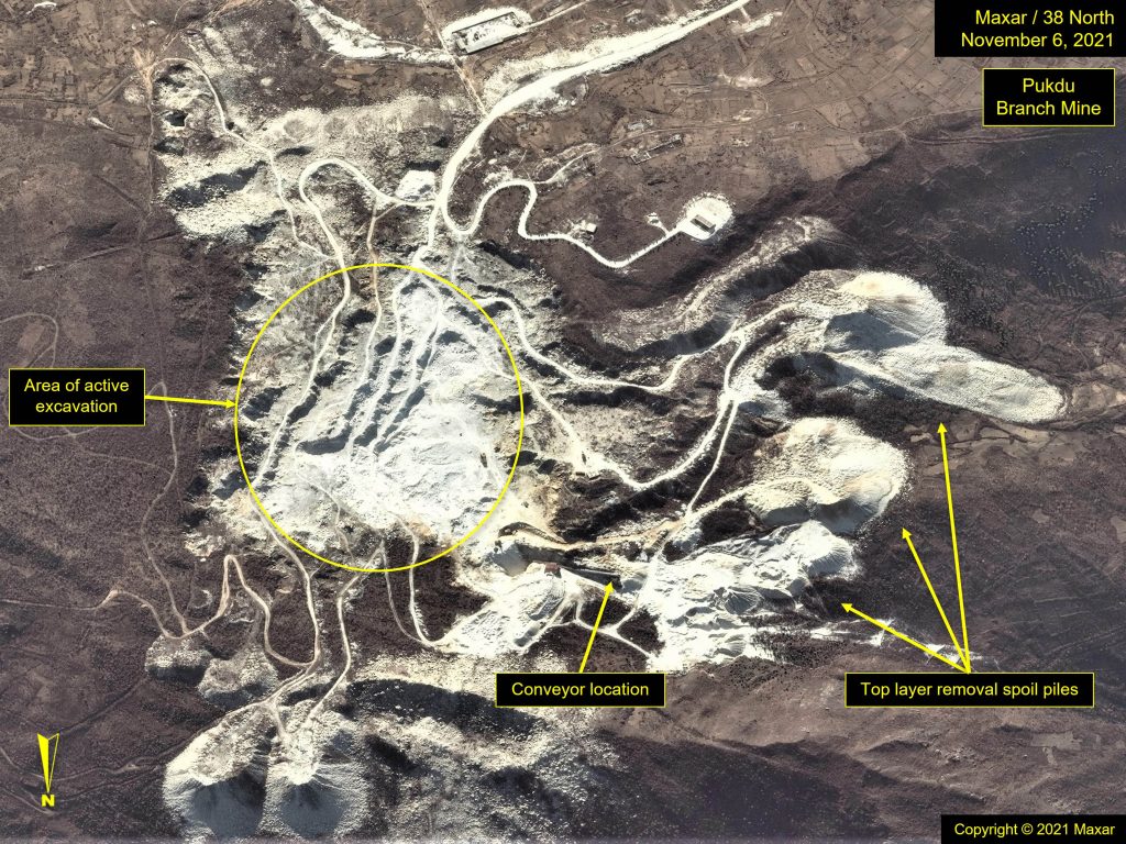
Magnesite is mined in both underground (e.g., Ryongyang) and open pit (e.g., Pukdu Branch Mine) mines (figure 7). A key product derived from magnesite is magnesia, an important component in basic refractories, animal feed supplements, fertilizer, insulation material, cement, and several environmental control procedures.
Figure 6. Ryongang Mines.
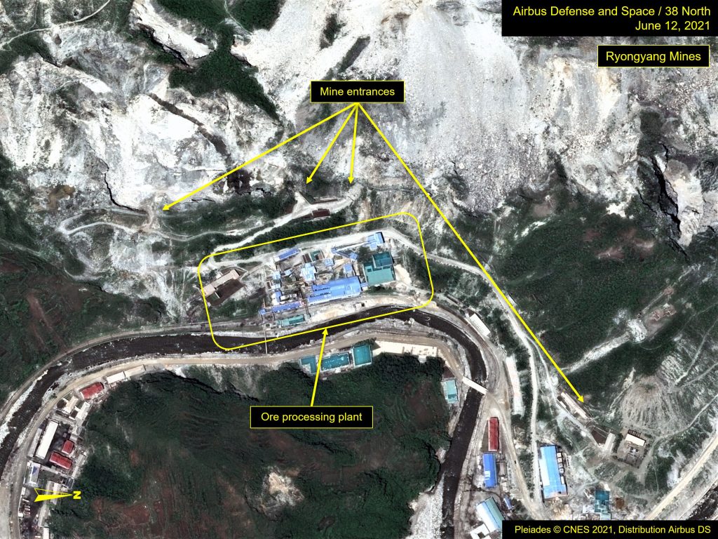
Figure 7. Pukdu Branch Mine.
Structural Issues for the Komdok Region
Flood Damage and Response
Flooding, in general, is a persistent problem in the region. But when typhoons strike, devastating floods can occur, such as what happened in 2007, 2012, and 2020.
Understanding the severity of the region’s topography is necessary to appreciate how flooding affects this area, but this can be difficult to ascertain from two-dimensional satellite imagery. At first glance, what appears to be a network of shallow streams and rivers meandering through a mountain valley is actually a riverine system that cuts deeply through extreme mountainous terrain. Gaining access to these mining valleys was a challenge from the start.
The roads and rail line that service the area, by necessity, follow the course of the river from the port city of Tanchon to points north of the Taehung mines. In several sections along the route, the roads and rail line hug the mountainsides, and pass-through tunnels have been constructed to shorten distances and reduce dramatic grade changes. Rail is the principal mode for moving the extracted ore to market, and therefore, maintaining the rail line is critical.
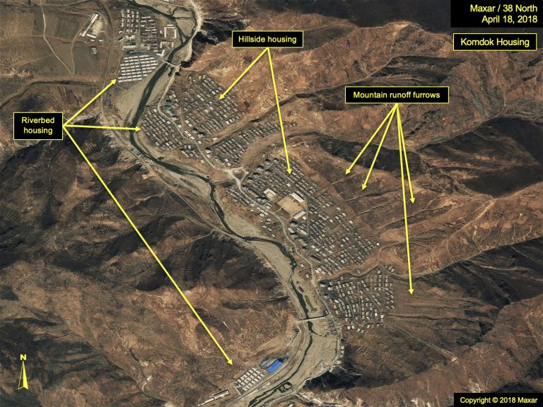
With its steep topography, this region is not ideal for large-scale human habitation or the building of factories. In order to successfully mine the area, finding or creating level ground to accommodate housing and processing plants has been necessary. Most commonly used are the wide, raised areas along dry river bends and the occasional gentler slopes found near the river (figure 8). Adjacent mountain plateaus have also been used, but those areas tend to be far removed from transportation networks (figure 9).
All of these locations come with risks, however. Seasonal rains commonly raise water levels and threaten facilities located in low-lying areas. To protect against rising water conditions, concrete flood walls have been constructed to help channel the water, and spoil from the mines is strategically placed to stabilize the riverbanks. But these measures, while effective against moderate, seasonal rains, often fall short against the more extreme conditions of typhoons.
Building on plateaus would thus seem preferable, but being further removed from the transportation network and dressing plants comes with a set of challenges. Access to these elevated areas is confined to dirt roads that wind up steep embankments and are slow to traverse and subject to washouts and landslides.
Figure 8. Examples of riverbed-based and plateau-based housing.
In addition, many of the local mining practices have exacerbated the potential for flood-related damage. For instance, much of the natural vegetation in the area has been stripped away as a result of the open pit mining found on the mountainsides along the river. During the rainy season, water runoff quickly mounts and can cause mudslides, which can damage buildings, roads, and rail segments.
Another concern involves three land reclamation efforts along the river south of Kumgol (example in figure 10). There, the river has been redirected through tunnels, bypassing wide river bends, leaving dry, level parcels of land to build upon. While these tunnels were designed to handle normal water flow, even during the rainy seasons, imagery shows that the torrents of water accompanying typhoons have overwhelmed them, as a dam-like effect is created, and flooding ensues in the areas above and adjacent to them. In other words, the site selections are disasters waiting to happen.
Figure 9. Example of land reclamation efforts.
Flood Damage and Recovery: 2012 vs. 2020
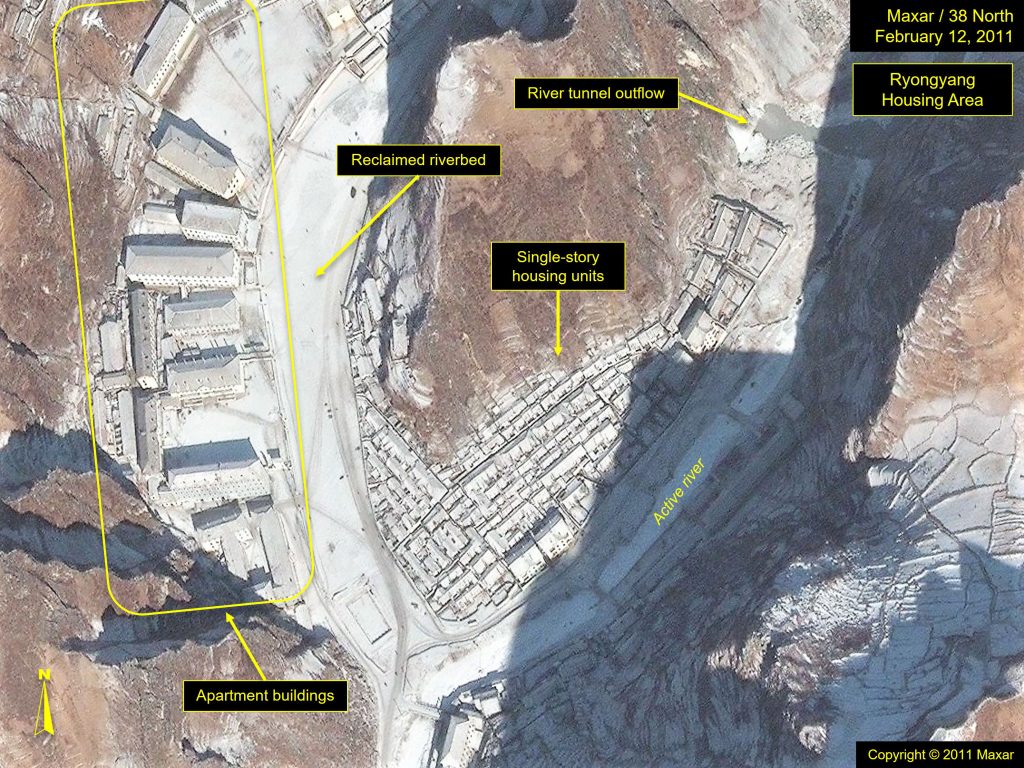
In 2012, at the end of a particularly heavy rainy season, North Korea was hit by Typhoon Bolaven. With wind speeds over 100 kilometers/hour, this caused widespread flooding and damage throughout the eastern part of the country. In imagery from after the storm, wind damage appeared to be minimal in terms of roof sections being lost. Housing closest to the river, in some cases, was washed away, but for the most part, structures remained intact (figure 11). This does not account for the level of water damage that was done to the building interiors, which would require imagery from the highwater-mark period to assess. However, in a few housing areas along the river, such as one south of the Ryongyang Mine, a number of single-story structures were eventually razed and replaced with multi-story structures, presumably from extensive flood-related damage.
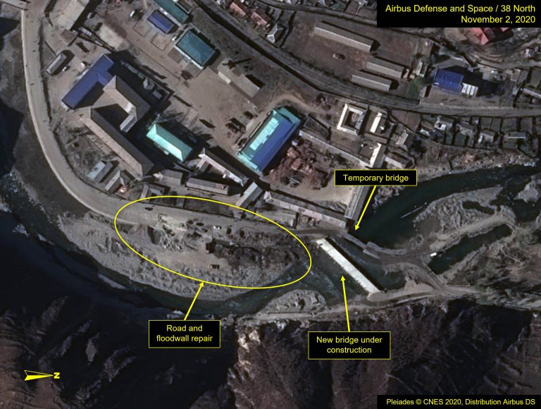
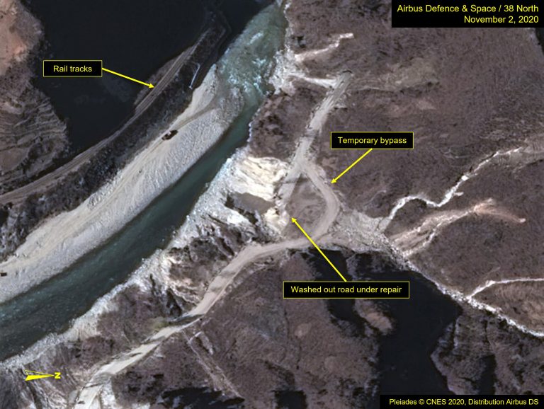
In 2020, North Korea was hit by back-to-back typhoons: Bavi and Maysak, wreaking havoc along the country’s east coast and sparking the country’s first-ever overnight live reporting (figure 14). In the Komdok region, the flood prevention measures put in place after the 2012 storm did not hold up to the series of stronger storms in 2020. More houses appeared to have been washed away accordingly, but the apparent “real” damage was to their interiors. Again, without imagery taken during the highwater-mark period, it is difficult to assess how many and how extensively homes were impacted. However, following Kim Jong Un’s visit in October 2020, significantly more houses were razed and new homes built than what was seen in 2012. While damaged bridges were quickly repaired, evidence of washed-out roadbeds remained as bypasses were created.
Following both storm periods, extensive work to reinforce flood walls and deposit spoil to build up the riverbanks was observed.
The government’s repair and recovery response within the Komdok region following the 2012 storm was similar to those following the 2020 storms, albeit not as pronounced in scope or scale. An exemplar is a housing area south of the Ryongyang Mine, where flood-related damage was significant, but the response was dramatically more extensive in 2020.
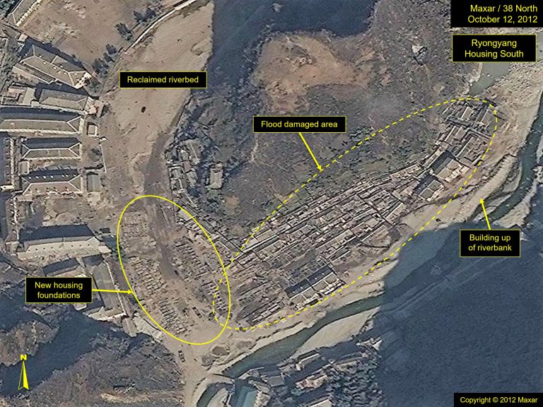
In the aftermath of Typhoon Bolaven in 2012, North Korean media reported efforts to construct 1,000 new homes (figure 12), whereas 25,000 new homes were promised following Typhoon Maysak (figure 13). In each instance, the focus on roads and railways was similar, but the visible damage appeared less widespread following the first. It is unclear whether the repair efforts in 2012 included mitigation efforts against future severe weather conditions. If there was, it was inadequate for the force of Typhoon Maysak in 2020.
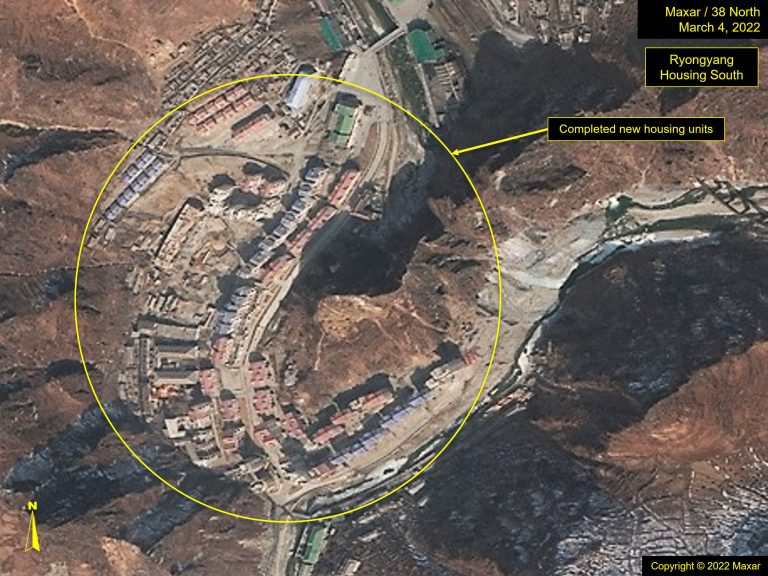
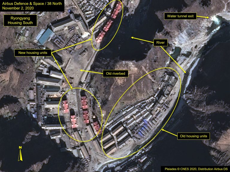
Figure 10. Ryongyang Housing South.
After Typhoon Maysak in 2020, Kim Jong Un visited Komdok to evaluate damage from the floods and set forth new initiatives for the region, a plan aimed to transform the area into “the country’s model mountainous city” next to Samjiyon, and make the Komdok Mining area the “world’s No 1 mountainous gorge city to be envied by all the people.”
He directed 25,000 new houses to be built in the Komdok Mining Complex, Taehung Youth Hero Mine, and Ryongyang Mine areas throughout the next five-year plan (5,000 houses per year). He also ordered a survey to properly design and rebuild the area to reduce flood risk in the future, stressing the need to dredge embankments, conserve trees and water, and build concrete retaining walls near roads and railways to protect against landslides and water damage.
Imagery from that post-flooding period showed this activity was, indeed, taking place. Roadwork and bridge repair happened almost immediately (figures 15, 16), and new housing started in several areas along the Komdok river valley (figure 17). Some imagery revealed workcamps had been erected, and vehicles could be seen along the river. But the biggest, most visible transformation was the speed at which new housing units went up.
Figure 11. Photo of flood conditions during Typhoon Maysak in 2020.
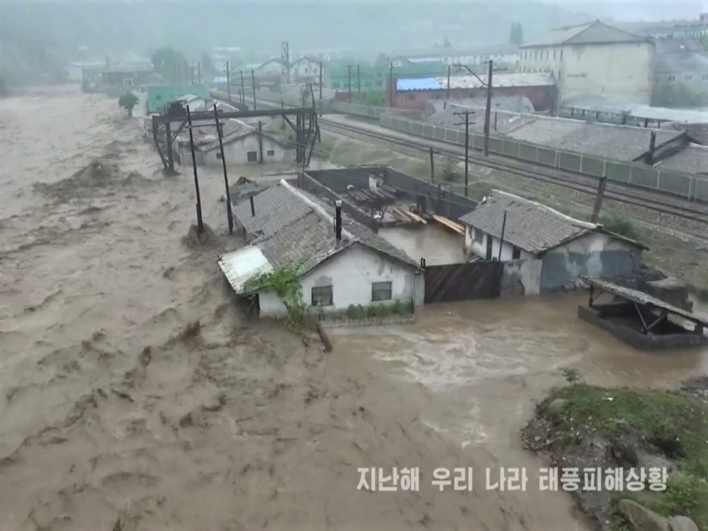
Figure 12. Post-typhoon repairs to roads, floodwalls and infrastructure.
Is North Korea Serious About Reviving the Area?
It appears that most of Kim Jong Un’s directives for the region are being met. During his initial visit to Komdok following Typhoon Maysak, he had set an October 10, 2020 deadline for the repair of roads, the rail line, and bridges, a promise which, for the most part, was fulfilled. In addition, the flood walls channeling the river were repaired, and spoil from the mines was used to build up the riverbanks. However, whether these measures will withstand a typhoon of a similar magnitude in the future is questionable.
While the Komdok region holds enormous resources and earning potential for the country, the terrain and way the region has been developed make flood prevention and storm damage an unavoidable reality without serious investment in engineering, infrastructure, and equipment.
Imagery shows that while the most favorable real estate has been allocated to the mining infrastructure, housing and public facilities sit on unstable ground, making living conditions for workers less than ideal, even with new homes.
New housing construction continues at a remarkable pace, but the speed at which these units have been built, particularly those built right after the typhoon, has come at the cost of quality. Unofficial media reports have suggested major structural issues with the new homes. In one instance, residents complained that second-floor apartments had no water, forcing them to draw water on the first floor. Other issues reported include insufficient furnishings and deep worries about how they will hold up to future storms.
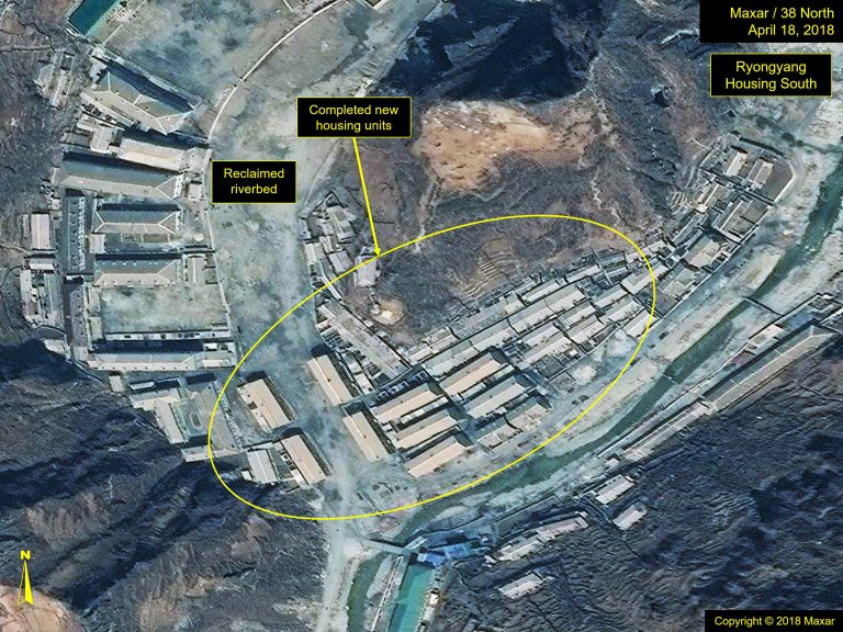
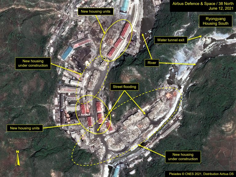
Satellite imagery appears to support these concerns. For instance, some of the first housing complexes built after Typhoon Maysak were quickly built in a reclaimed river bend (figure 17). However, less than a year later, following the spring rainy season, standing water was observed in the streets, portending the risk of future flooding in the face of severe storms (figure 18). Despite this, further housing units continue to be added to this area with no visible mitigation efforts being put in place.
Figure 13. New housing in Ryongyang Housing South.
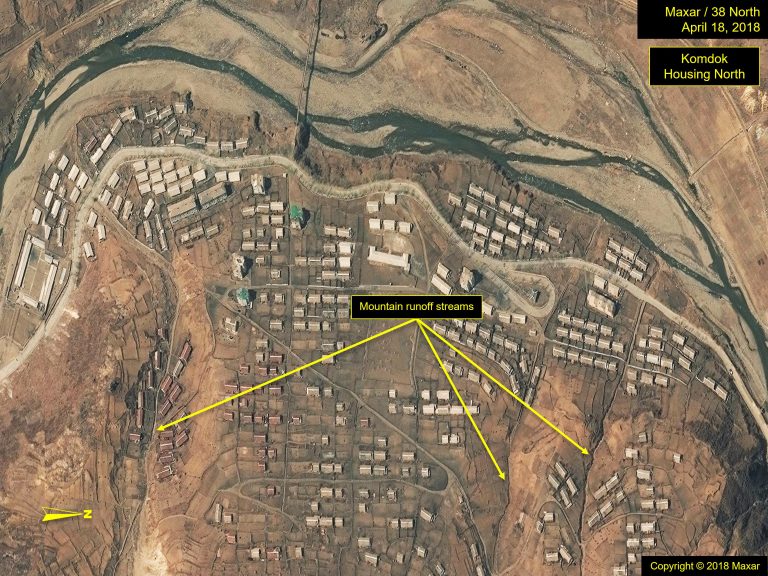
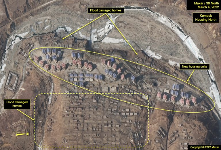
Another example is the new apartments being constructed on slopes along the river. Previously, there were single-story units built in this area, where runoff furrows were clearly visible (figure 19). While a few of the early units were swept away during past storms, mud covered most of the remaining units, suggesting water likely passed through them, making them uninhabitable. Erecting modern, attractive apartment complexes may be visibly inspiring, but many of the runoff furrows remain, and there do not appear to be any efforts underway to redirect the water runoff away from the new housing complexes (figure 20). This suggests they are likely to suffer the same fate as the predecessor units, albeit perhaps with damage limited to their first floors.
Figure 14. Komdok Housing reconstruction efforts.
Modernization and Increased Production?
Absent information provided through North Korean media regarding plant and mine modernization efforts and increases in production, detecting such changes or even verifying the reporting via satellite imagery is difficult without near daily collection to track movement and patterns of life. This is particularly true for monitoring fleeting items such as rail rolling stock and its cargo. Terrain changes at open pit mines caused by blasting and excavation of new pits can be subtle without a major effort being undertaken. Upgrades to processing plants and other factories tend to be longer-term in nature, but changes to building exteriors are merely an indicator of change, they do not necessarily provide clues as to what changes or upgrades might be occurring inside. Even assessing flood damage is limited to a structure’s exterior, as the status of its contents cannot be seen. When a building is left largely intact following a storm, determining its operational status is ultimately left to exterior signatures such as smoke emissions and/or products being staged outside.
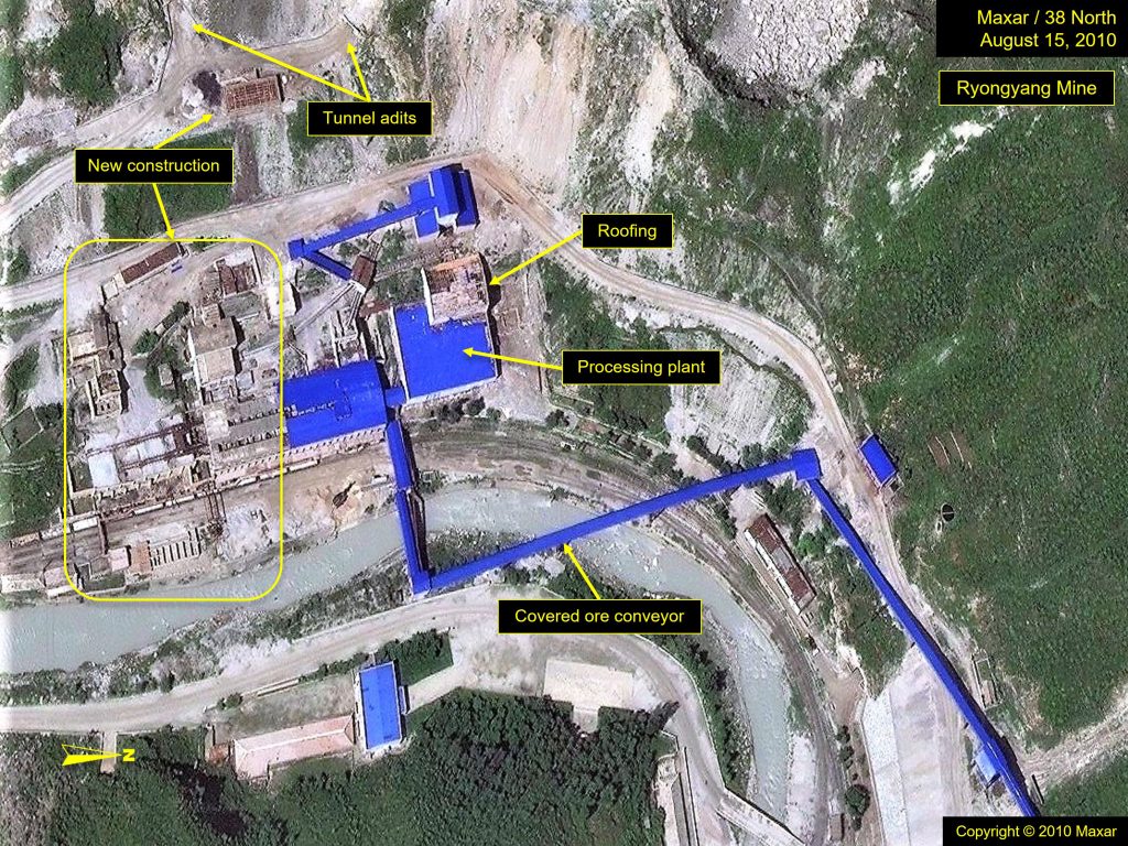
The Ryongyang Mine is an exemplar of the gradual change seen at the mining complexes in Komdok. Imagery taken in 2010 shows the mine and processing plant under expansion, with new, covered conveyors in place to move ore (figure 15).
Figure 15. Ryonyang Mine in 2010 with covered conveyor.
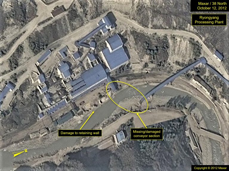
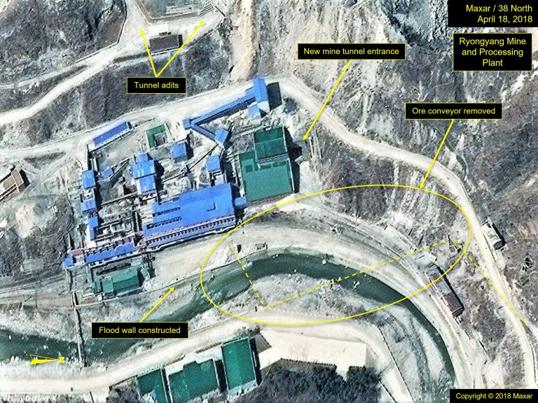
Imagery from after the 2012 typhoon shows that most of its mining facilities had been completed; however, the lower section of the conveyor, which crossed the river, had been washed away in dramatic style (figure 22). While repairs to the floodwalls were ongoing in April 2018, with reinforcements made after Typhoon Maysak, no attempts to repair the conveyor could be detected. In fact, imagery taken in 2018 revealed that the entire conveyor system had been removed (figure 23). It appears a new tunnel adit had been opened adjacent to dressing facilities to access the mines. What is not clear is whether the new tunnel entrance is accessing the same magnesite vein or whether the previous tunnel entrance, serviced by the conveyor, was to a separate vein, which has been near mined out, and the damage caused by the 2012 typhoon hastened the change. At the same time, other conveyors servicing other mines in the Komdok region, such as the Tonsan Mine, have also been removed. This may signal a change in mining practice, although conveyors are still present at the Kumgol Mine.
Following Typhoon Maysak in 2020, imagery showed additional improvements to the flood walls were being made, and new spoil piles had been deposited along the riverbank in an effort to shore it up (figure 24). Given its relatively high location above the river, and despite the erosion of the riverbank, no visible damage to the mining facilities themselves was detected, save for the conveyor. With its removal and a new tunnel entrance, there had clearly been changes in mining operations, but the exact nature of those changes is unclear. Interestingly, however, covered conveyors were removed from multiple mining locations around 2018. So, perhaps new practices were being adopted across the region.
Figure 16. Improvement and modernization efforts to the Ryongyang Mine and Processing Plant from 2012-2022.
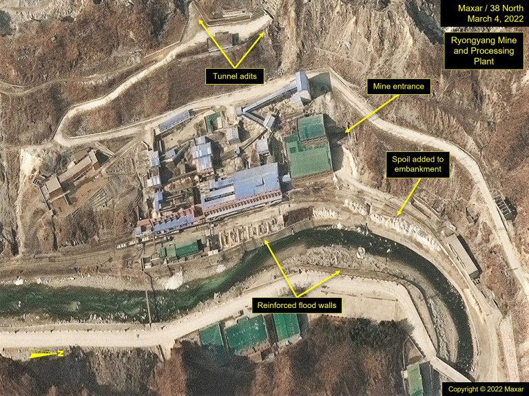
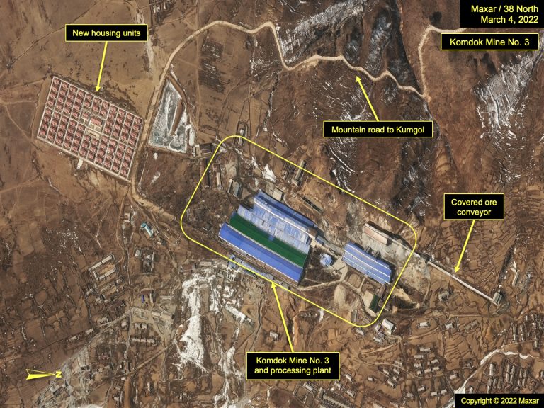
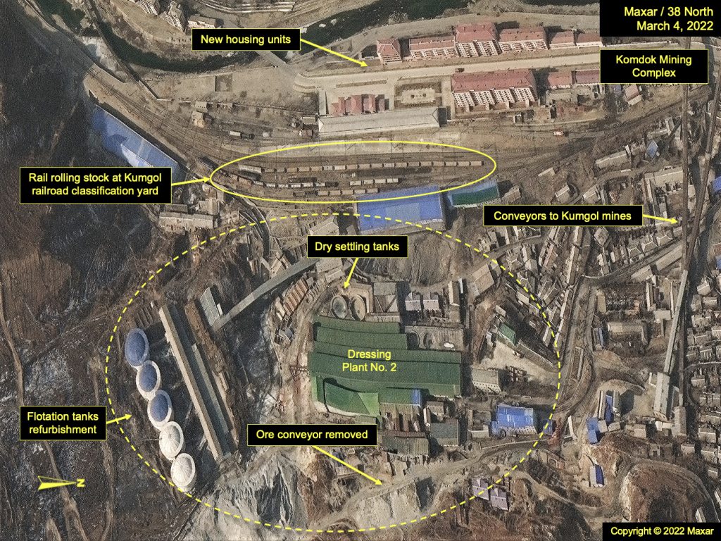
As for the other mining complexes following Typhoon Maysak, most of the repairs seen in and around the mines have not been directly related to the mines, but rather toward the reinforcement of the river embankments and restoration of roads, bridges, and rail. Minor construction has appeared at the Taehung processing plant and the Tonsan Mine, although none that would suggest modernization. In Kumgol, two of the more notable changes include the addition of a workers’ village adjacent to Komdok Mine No. 3, and five floatation tanks have been refurbished at the dressing plant, visible on imagery from March 2022. Moreover, the covered conveyor was removed. Rolling stock has returned to the rail yard at Kumgol, confirming that it is still operational, but additional imagery would be needed to determine the impact on production (figure 17).
Figure 17. Rail rolling stock observed at the Komdok Mining Complex and refurbished flotation tanks at the dressing plant indicate ongoing operations.
An insufficient supply of electrical power has plagued North Korea for years, and the Komdok region is no exception. Inadequate energy sourcing has been a perennial problem, limiting the area’s production, and claims of new processing techniques being implemented, reducing energy needs by half, cannot be substantiated. While changes to the energy infrastructure would be a key indicator of a commitment to increase operational capacity and improve the quality of life of the miners and their families, imagery taken over the last decade reveals few developments in this area. No new substations or power plants have been added, although some upgrades to existing substations may have occurred but were not detected due to limited imagery coverage.
In an effort to improve energy provision to the northeast provinces, new hydroelectric power stations are gradually being added to its grid; among those are three power stations on the Namdae River. It is unclear whether any of these new stations have become operational or whether they will provide additional capacity to the Komdok mining community needs, but power lines do connect their location with a large substation south of Kumgol.[1]
Looking Ahead
If North Korea is serious about reviving the mountainous and flood-prone Komdok mining region, it will need to invest in more than just expanded worker housing and band-aid repairs. For instance, hardening or paving the dirt roads would help improve access to the more remote areas. Building new rail lines to additional ports and distribution hubs, such as Nampo Port or Namyong, to facilitate land-based exports to China would support broader distribution if and when prospects for exports improved. However, to actually increase production in this region and maximize its potential, consistent energy provision and the infusion of new and more modern equipment and methods are badly needed. Building this infrastructure, however, is not a turnkey process but rather a long-term endeavor. Moreover, planning for and implementing sound flood-prevention measures and protocols for this challenging terrain is necessary to truly transform Komdok into a “model” mining community and realize its enormous economic potential.
Things To Watch
- Will larger flood walls be constructed along the river to prevent flooding?
- Will additional new housing be located in more secure locations and provided with a transportation infrastructure necessary for the workers who live in them?
- Will efforts be made to stabilize the landscape bordering the road and rail network to prevent or reduce washouts?
- Will the number of processing plants increase, and/or will existing plants be expanded?
- Will the number of electrical power substations increase, and/or will the existing ones be expanded?
- Will we see an expansion of the port at the city of Tanchon to facilitate exports?
Data Sources
kml Komdok Mining Area Annotations
shp Komdok Mining Area Annotations
The Stimson Center and the National Geospatial-Intelligence Agency partnership uses unclassified imagery and data to produce new, timely, and accurate reporting on the North Korean economy. For more info, read the Tearline Project Explainer.
To read more, visit NGA’s Tearline article or download the Tearline app from the Apple Store or Google Play.
This content also syndicates to the Office of the Director of National Intelligence’s website intelligence.gov, which is a transparency effort to better explain certain strategic and humanitarian IC missions to the public.
- [1]
First mentioned in Kim Jong Un’s New Year’s address in 2016, the hydroelectric Tanchon Power Station project is adding three new power stations to an area co-located with Hochongang Power Station No.1 in Suram-ni, which is located approximately 35 kilometers to the west of Komdok. While the power generated will service the broader region, a set of power lines do link the Tanchon power project to a major substation at Komdok. See “Kim Jong Un’s New Year Address, Rodong Sinmun, January 2, 2016.