Pyongsan Uranium Mines: Mining Continues as Older Mines Are Renewed
Commercial satellite imagery of North Korea’s Pyongsan Uranium Mining area indicates that mining operations at the main uranium mine (Mine 1) continue and that the Uranium Ore Concentration Plant, which is used to produce uranium concentrate (“yellowcake”), is still active. Additionally, since 2020, new activity has been observed at three mines in this area that have appeared dormant since 2003.
A recent report suggested that newly caved-in areas around Mine 5 indicate the area has been “mined out,” none of these new sinkholes appear to affect any active mining operations.
The Pyongsan Mines
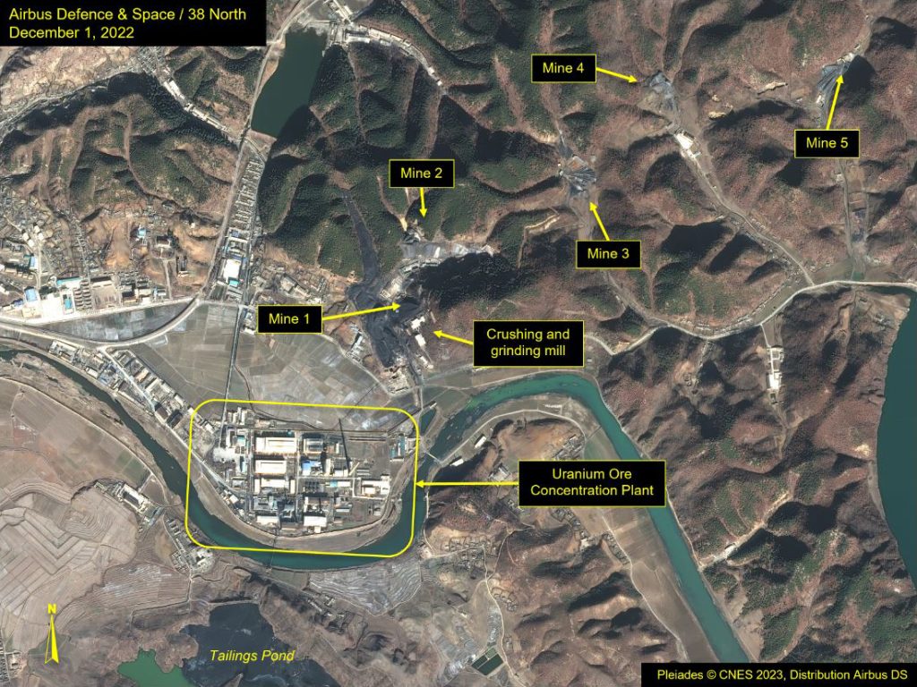
There are five identifiable mines in the mountain range that extends from the north to east of Pyongsan from which uranium-rich coal is extracted. The signature for locating these mines and assessing their operation level is the coal and excavated spoil found near their entrances.
The record of available commercial satellite imagery begins in 2003, and all of these mines were present at that time. For the purposes of this report, the largest and nearest mine to the concentration plant will be referred to as Mine 1. A second mine, immediately north of the first, is Mine 2. Mine 3 is located 700 meters east northeast of 2, Mine 4 is approximately one kilometer farther to the east, and Mine 5 is yet another 700 meters farther to the east.
Figure 1. Overview of Pyongsan’s five mines.
Mine 1 appears to have been the only one active during the entire period imagery has been available, evidenced by the continued changes in the spoil piles found outside the mine entrance.
Mine 2 appeared inactive from 2003 until the spring of 2021. In April 2021, new support buildings were being erected around the mine’s entrance. There has been no increase in the coal spoil around the mine, but by mid-May 2022, a light-toned substance was visible around the new support structures, and a brown runoff slurry (perhaps groundwater) had been pumped from the mine. It is probable that the light-toned substance is another rock type adjacent to the coal ore.
Mine 3 appeared inactive until the spring of 2020. Vehicle tracks were observed, but little, if any, growth to the spoil piles from the mine occurred at that time. By October 2022, a new building and an adjacent structure had been constructed, and a new pipe was observed connecting the new building to the old mine entrance building.
Mine 4 is the only mine that has seen no change since 2003, suggesting it has been mined out. While there is a nearby compound with several buildings, no active roadway connects it to the mine.
Mine 5 has seen the most recent changes. Like the others, it appeared to be inactive until late 2020, when a small growth in the spoil was observed. Additionally, one new support building was added in September 2020; a second had been built at the mine entrance by July 2021, and a third, perpendicular to the others, by September 2021. By May 2022, a large new spoil pile had been formed—a clear indication that the mine was active and productive.
Figure 2. Activity at Mine 5.
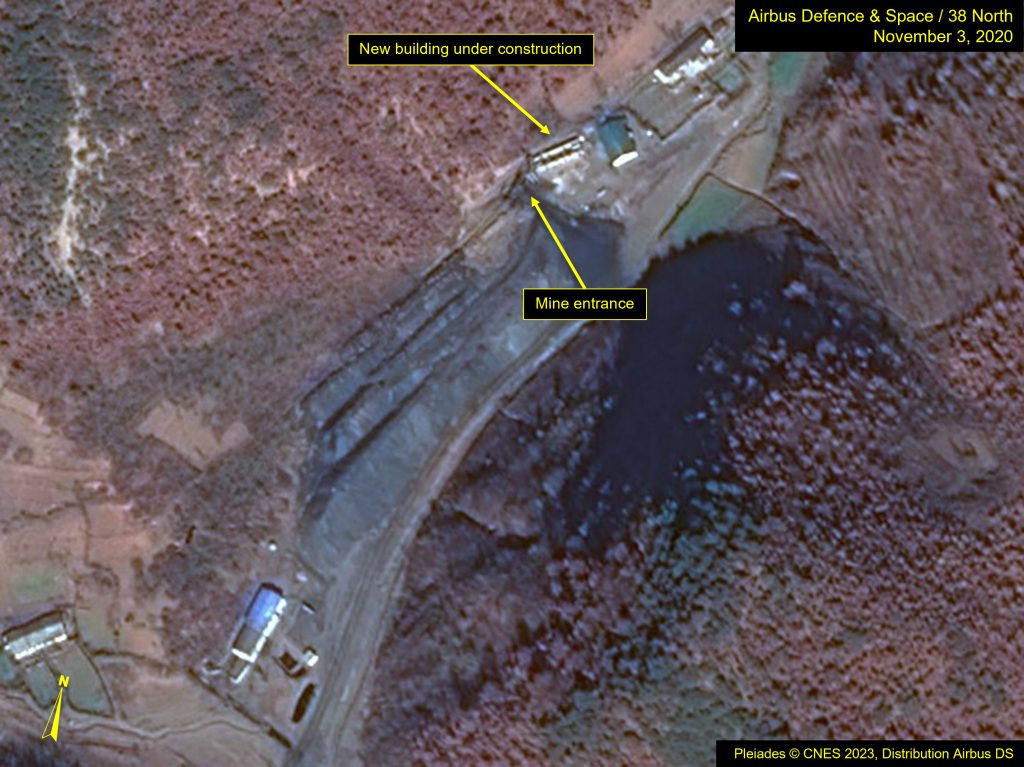
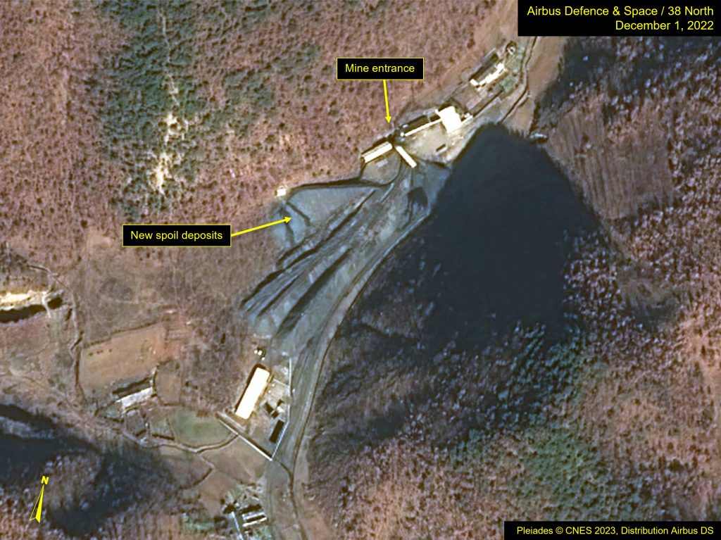
Image Pleiades © CNES 2023, Distribution Airbus DS. For media options, please contact [email protected].
The Uranium Ore Concentration Plant
Imagery from December 1, 2022 and January 21, 2023 reveals that the Uranium Ore Concentration Plant, located immediately southwest of the mines, remains active. A raised uranium ore slurry pipe connects the crushing and grinding mill, located adjacent to Mine 1, to the plant. Satellite imagery offers few observable indicators of the plant’s operational status. Dust and chemical stains around the roof vents of a number of the buildings reveal use but change little between coverage. And while there are several exhaust stacks within the complex, emissions from them are rarely detectable.
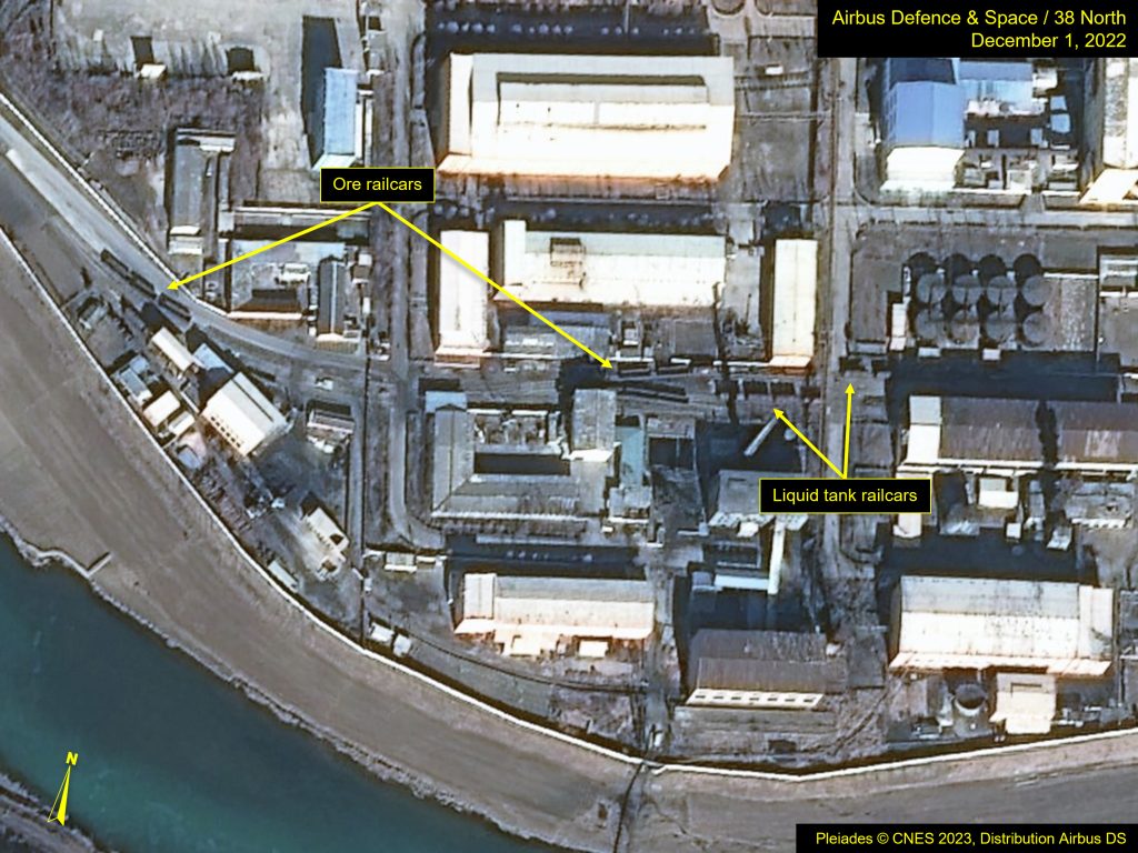
However, there are two more obvious indicators of continued plant operations. These include the continuous movement of railcars within the plant complex and an ever-growing amount of discarded liquid sludge or tailings into a large artificial tailings pond located across the river south of the plant. The railcars are principally ore and liquid tank cars and routinely observed at various locations within the complex or captured entering and/or leaving the plant compound.
As an exemplar, more than a dozen of these railcars were observed within the plant compound on December 1, and on January 21, approximately 20 railcars were queued to enter the complex. During this period, multiple images captured similar movements.
Figure 3. Railcars observed at the Uranium Ore Concentration Plant on imagery from December 1, 2022.
Crushing and Grinding Mill
A key component of uranium mining is the crushing and grinding of the coal ore. The uranium-rich coal ore is brought to the mill for further refining. The mill is located adjacent to Mine 1, where ore can be moved to it easily. The other mines require their ore to be trucked to this mill.
As the ore is refined, it is mixed into a slurry and then moved by an elevated pipe down to the concentration plant. The waste rock from the milling, also called overburden, is moved by truck to a spoil dump immediately north of the mill. Large coal stockpiles are located directly outside the mill, which constantly fluctuate in size and shape as the ore is brought for processing.
The fluctuation in the coal stores and the growth of waste rock spoil deposited in the adjacent valley provide a record of ongoing activity. For example, from April 2020 to April 2021, the 380-meter-long overburden spoil pile grew by 115 meters in length and from 30 to 40 meters in width. Unfortunately, the percent of uranium separated from this overburden is unknown, and the total volume of this waste rock has not been assessed; however, it does not appear that there has been any decline in output.
Figure 4. Uranium coal stockpiles and excavated spoil on November 3, 2020 and December 1, 2022.
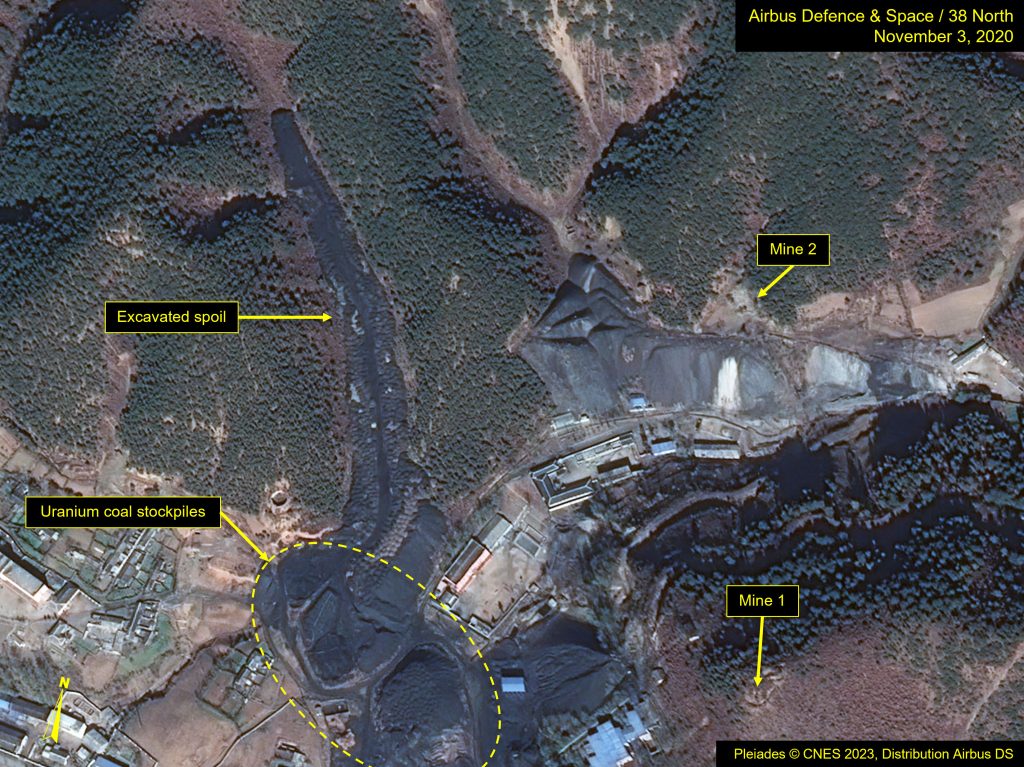
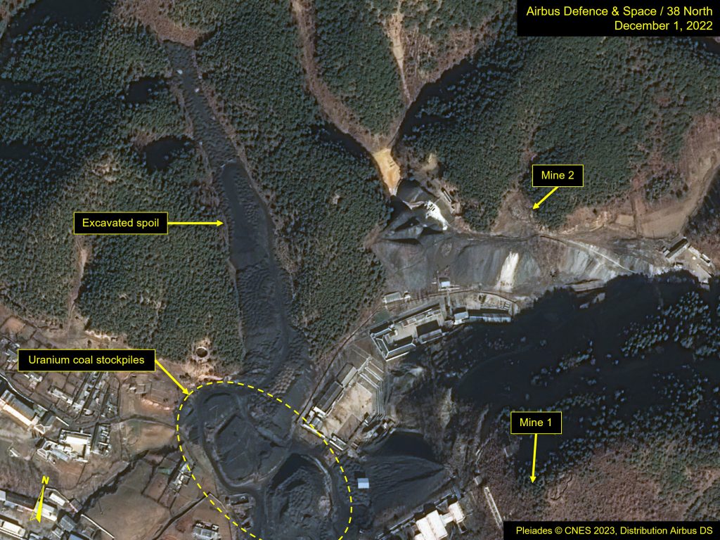
Image Pleiades © CNES 2023, Distribution Airbus DS. For media options, please contact [email protected].
Tailings Pond
The waste tailings pond, located south of the Uranium Ore Concentration Plant, was built to avoid polluting the adjacent river. The waste slurry is pumped across the river via pipe to a large holding pond, where much of the pollutants separate out as the pond water seeps into the soil, and the excess makes its way via small streams into the river further to the east. The waste sludge tends to settle to the north side of the pond near the main outfall, so the growing size of tailing provides a measurement for activity at the plant.
Imagery from October 2020, after a series of strong typhoons, revealed stress areas at the dike on the east side of the pond, where apparently some overflow of water had occurred. In May 2022, construction on the east side of the dike of what may be a small pump house and trenching for a drainage system had begun. By December, the project appeared to be completed.
Figure 5. Activity at Tailings Pond visible between November 3, 2020 and December 1, 2022
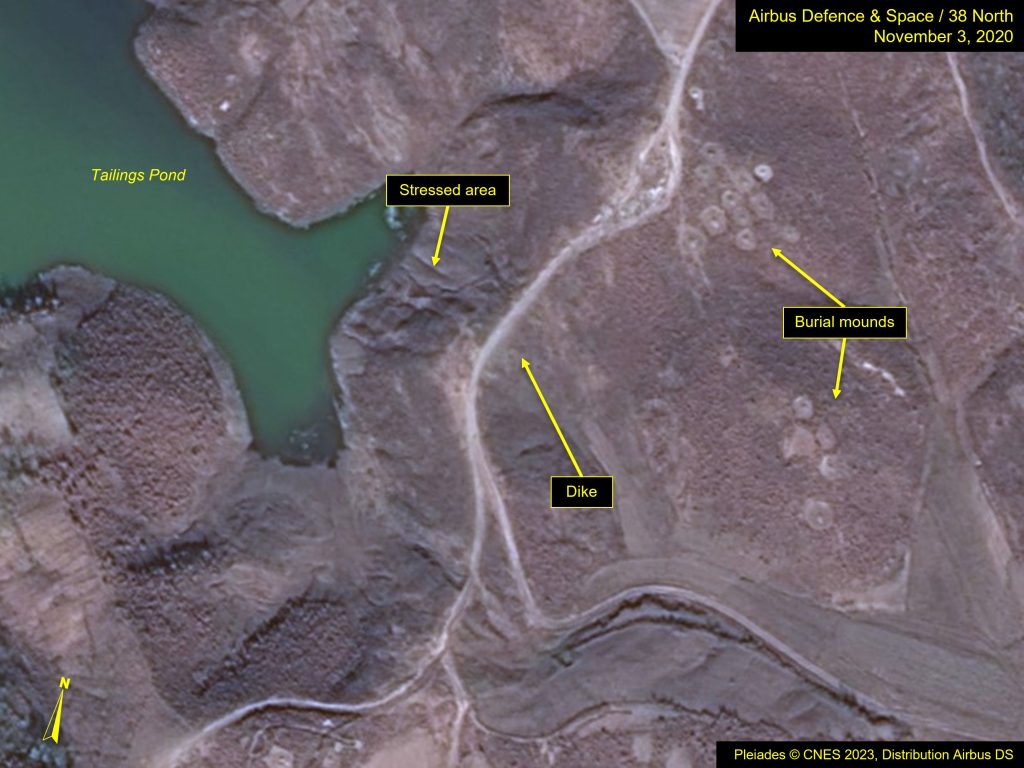
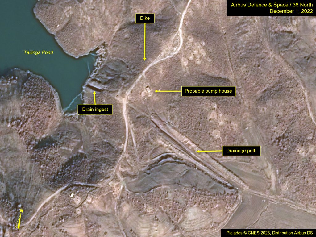
Image Pleiades © CNES 2023, Distribution Airbus DS. For media options, please contact [email protected].
Surrounding Geologic Activity
The stretch of hillside between Mines 4 and 5 has experienced geological shifts and subsidence over the past two decades. A series of four landslides forming sinkholes is located along that stretch. The largest is located farthest to the east, and the other three are clustered to the west. The smallest and largest sinkholes predate 2003. The latter had actually been comprised of several smaller ones, which gradually expanded into one.
A third sinkhole, one of the cluster of three, appeared in 2019. In March 2021, the smallest of the group suddenly expanded, becoming more visible, and that June, a fourth sinkhole opened up.
There are no mines or their spoil directly related to this area. They are also not linear in occurrence, meaning these sinkholes are not likely related to tunnel cave-ins. The more recent openings seem to coincide with the renewed activity at Mine 5, making it likely the use of explosives during mining operations that triggered the soil movement.
Figure 6. Sinkholes between Mines 4 and 5.
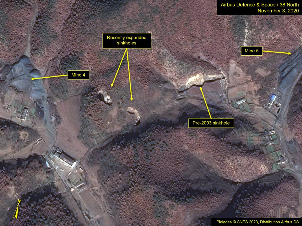
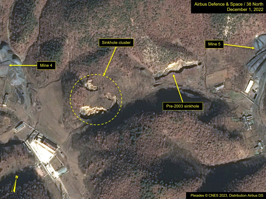
Image Pleiades © CNES 2023, Distribution Airbus DS. For media options, please contact [email protected].