New Evidence that North Korea Could Still Conduct Nuclear Tests at Punggye-ri
Newly acquired synthetic aperture radar data of the Punggye-ri Nuclear Test Site provides additional evidence that the two mountainous areas accessible by the South and West Portals remain viable, and could support future underground nuclear testing if there were to be a political decision to do so. The data also corroborates Kim Jong Un’s publicly reported statement that two tunnels of the site remain in good condition. In short, while Chinese seismological findings that the Mt. Mantap portion of the nuclear test site may no longer suitable for tests due to significant damage and deformation appear correct, claims that the entire site “is wrecked beyond repair” are wrong.
The Chinese Findings
Two Chinese seismological research groups recently released assessments of the September 2017 nuclear test in which they independently concluded that a 4.1 magnitude earthquake detected eight and a half minutes following the nuclear test was caused by a cavity collapse under Mt. Mantap peak. One also suggested that monitoring for “the leakage of radioactive materials” should be continued as a result of this collapse. Nowhere in these findings were any comments made on the viability of the overall test site for future underground nuclear testing, or were any claims made that “the test site ‘collapsed.’”[1]
However, another researcher, Zhao Lianfeng, with the Institute of Earth Science at the Chinese Academy of Sciences in Beijing, was quoted as saying that, “the two studies supported a consensus among scientists that ‘the site was wrecked’ beyond repair.”
The Data Suggests Otherwise
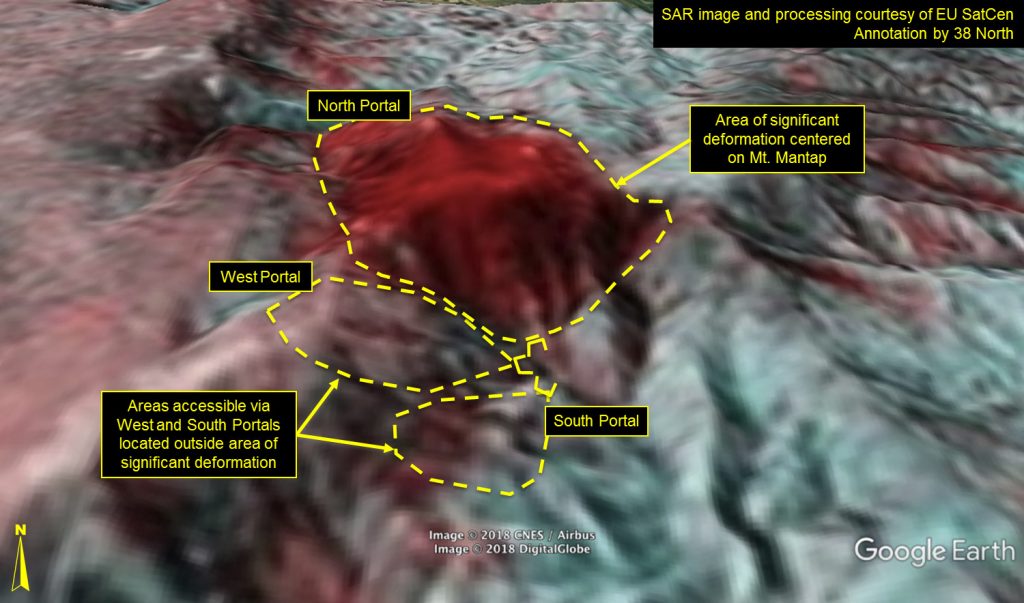
Five of North Korea’s six known underground nuclear tests, including the largest one conducted in September 2017, were conducted under Mt. Mantap and supported by a tunnel system accessible via the North Portal. Commercial satellite imagery has indicated the North Portal seems to have been abandoned since that last test. However, as we have also previously reported, two unused mountainous areas, accessible via the South and West Portals, appear to remain viable in more pristine rock located approximately 2.5 and 3.5 kilometers from Mt. Mantap’s peak.
An interferometrically processed radar image of the Punggye-ri nuclear test site (Figure 1), provided by the European Union Satellite Center (EU SatCen), shows differential changes in elevation, before and after the last nuclear test, demonstrates that point. The red in the figure indicates significant deformation/displacement and likely rock fracturing in the Mt. Mantap area, where the most recent nuclear test occurred. However, the figure also shows that the areas accessible via the South and West Portals have not been similarly disturbed.[2]
It should be noted that there was substantial tunneling at the West Portal beginning shortly after the sixth nuclear test, and up to at least early March 2018, as evidenced by rapid growth of the adjacent spoil pile. At no time was there any observable evidence of a halt to the tunneling due to tunnel collapses as had been also reported in the media. The most recent commercial satellite image of the site showed about a dozen mining carts out on that West Portal spoil pile clearly indicating that tunneling was still being conducted until only quite recently.
Figure 1. EU SatCen interferometrically processed ALOS-2 SAR images from August 29, 2017, September 12, 2017 and September 26, 2017 and overlain them on Google Earth to show the September 3, 2017 nuclear test effects at Punggye-ri.
- [1]
For instance, a Financial Times article’s headline specifically stated, “North Korea nuclear test site said to have ‘collapsed.’”
- [2]
Inelastic deformation falls off with distance from the epicenter of the previous event with the distance dependent on the yield of the event. “We can distinguish a zone of inelastic deformations of rock mass (situated at distances to 120-130 m/kt 1/3, and in isolated directions may reach 150 m/kt 1/3)”, which for a test having a yield of ~250 kilotons would be under a kilometer and the “changes in properties of rocks and rock masses in the vicinity of previously conducted underground explosions impose certain requirements on selection of a location for conducting underground tests. The location of a new test must be chosen such that zones of increased fracturing of the rock mass from previously conducted explosions do not intersect with the planned explosion.” https://pubs.usgs.gov/of/2001/0312/report.pdf