The Punggye-ri Nuclear Test Site Destroyed: A Good Start but New Questions Raised about Irreversibility
North Korea completed the destruction of the last three remaining tunnels as well as a number of buildings at the Punggye-ri Nuclear Test Site on May 24. As part of the site destruction, foreign journalists at Punggye-ri were shown a large-scale topographic map displaying the layout of the tunnels used to conduct North Korea’s six acknowledged underground nuclear tests and the steps undertaken to shut down the site. The map provided never before seen details and admissions regarding the suspected test tunnel trajectories and the precise geolocations of each of the six tests confirming previous analyses by outside experts. It also provided no indication of a secondary portal in the South Portal area, which we had previously suspected might be present.
However, a number of important questions remain that go to the issue of whether the destruction of Punggye-ri is irreversible.
- First, while the tunnel portals were clearly closed, the extent of damage to the tunnels internally is unverifiable. The briefing map presented by the North Koreans specified that explosives would be placed at varying intervals deep inside the tunnels, and from the videos it appears that there were secondary blasts beyond the portals roughly 15 seconds after the initial destruction took place. But the extent of that internal damage remains unclear and would certainly be an important activity for any subsequent visits to the site by experts, should that be permitted.
- Second, there appear to be discrepancies regarding the depicted tunnel lengths at the North Portal versus the West Portal vis-à-vis the size of the accumulated spoil pile associated with each portal. While measuring spoil piles is one method to determine the scope of underground facilities and is certainly not fool proof, that discrepancy raises questions as to whether more tunneling took place under Mt. Mantap than what the North Koreans have admitted.
- Third, the secure two-story Headquarters Building at the Command Center and numerous support camps within the test site appear untouched. It is unclear why such key nuclear test-related support facilities were not shown to the journalists, and why they were not destroyed at the same time as the other support facilities in the tunnel areas. Although it could be argued that the personnel left behind to guard the site will use this infrastructure, the fact that these facilities remain leaves open the question of could they be part of a contingency plan to shorten time needed to resume nuclear testing at Punggye-ri at some point in the future.
These lingering questions point to the need for a more detailed and methodical effort by experts to insure the test site closure is as irreversible as possible.
Pre- and Post-Demolition Imagery Findings
Commercial satellite imagery from May 23 and May 28 showed the final preparations before, and the results of the explosive closure of North Korea’s Punggye-ri Nuclear Test Site afterward as witnessed by foreign journalists.
Imagery before the demolition shows:
- The completion of the main probable observation stand to view the North Portal, and other less elaborate positions for journalists to observe the explosive closure of the other West and South Portals as well as the destruction of the Main Administrative Area;
- The erection of a welcoming venue including a line of tents and canopies in the lower courtyard of the Main Administrative Area;
- False fronts with doors over what were previously open portals;
- The completion of small white sheds in each area which we now believe served as rest buildings for the visiting journalists; and
- the beautification of the site involving the removal of extraneous or unsightly buildings, grading of various areas and the planting of numerous trees and bushes.
Following the explosions, imagery shows:
- The remains from the demolition of the portals to the North, West and South test tunnels along with two support buildings as well as the Main Administration Area;
- The continuing presence of the wall-enclosed Command Center with its two main buildings intact including a two-story Headquarters Building; and
- The continuing presence of several other unidentified buildings near the Main Administration Area as well as other support facilities, barracks and security checkpoint buildings.
Figure 1. Overview of the Portal Areas at the Punggye-ri Nuclear Test Site.
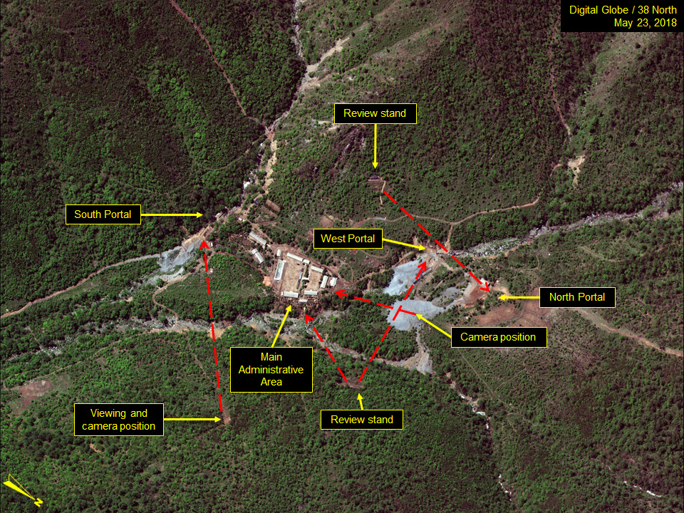
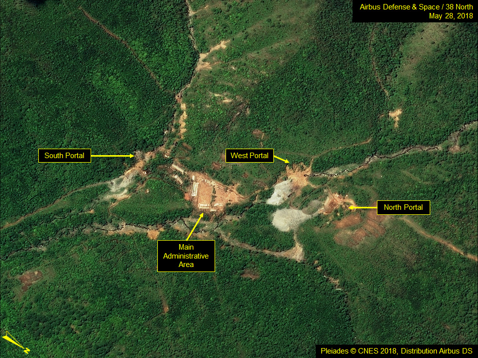
Figure 1 provides an overview of the northern section of the Punggye-ri Nuclear Test Site showing the areas of the test site visited by foreign journalists and the views afforded from each camera position. Those four areas viewed and toured pre-and post-demolition included the North Portal Area, the West Portal Area, the South Portal Area and the centrally located Main Administrative Area.
North Portal Area
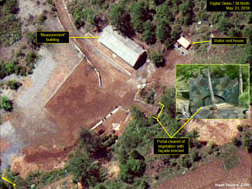
Between May 21 and May 23, discernable changes involved the completion of a new small white shed similar to those at the other three areas which were likely intended as visitor rest houses, new grading of the area directly in front of the North Portal and the planting of bushes out on the spoil pile.
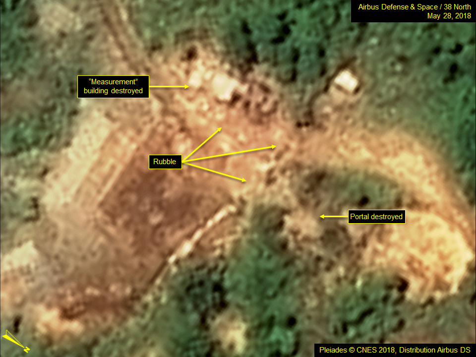
Imagery from May 28 shows the North Portal had been explosively closed and the nearby “measurement/recording” building was blown up as well. There was no evidence provided to the journalists to determine what role the building actually served, but we have previously identified the structure as compressor building to provide ventilation to the tunnel system. (Figure 2)
Figure 2. North Portal area before and after dismantlement.
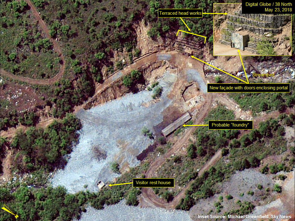
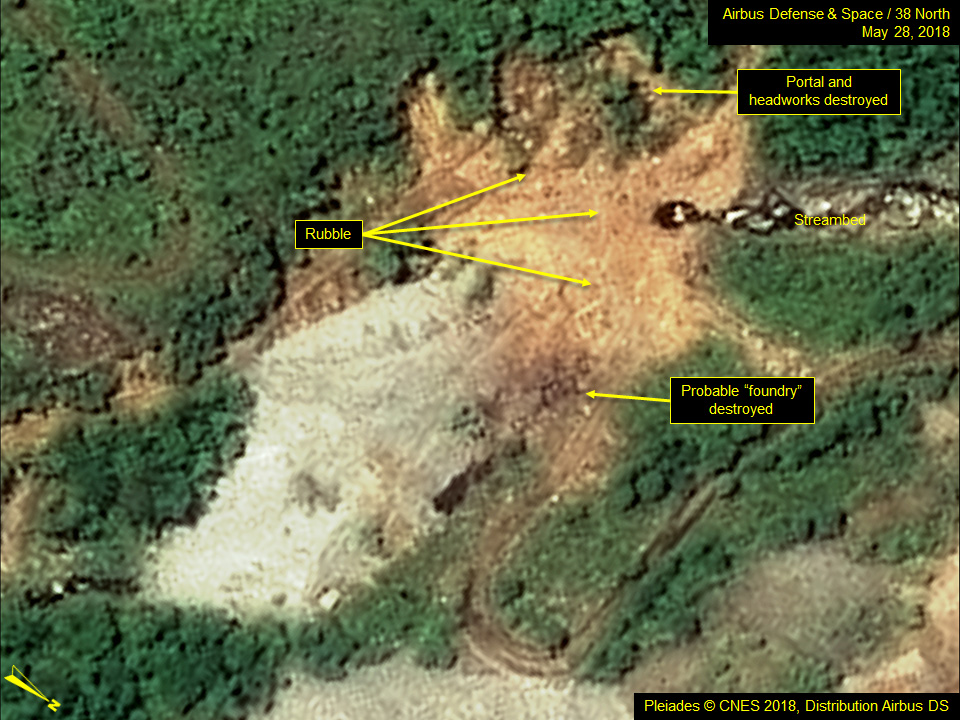
West Portal Area
By May 23, what we had thought was a new shelter erected directly over the West Portal tunnel entrance was shown in ground imagery to be a new camouflage-painted entrance façade with doors to enclose the portal. Both the façade and the portal it enclosed, along with the entire surrounding terraced hillside, were destroyed with chemical explosives. (Figure 3)
Figure 3. West Portal area before and after dismantlement.
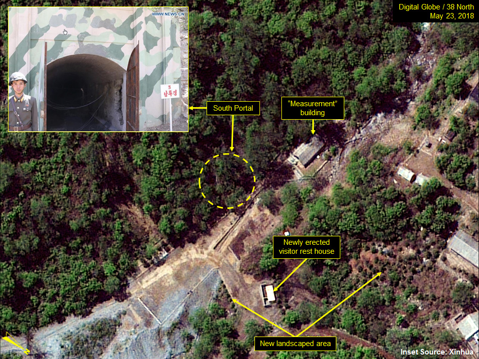
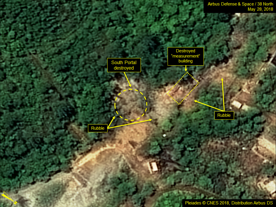
South Portal Area
The South Portal Area had also been cleaned up with new landscaping and guardrails in some locations. It has always been difficult to precisely locate the portal (entrance) in this area due to thick tree cover and shadows and there was some evidence to suggest that there could be a secondary portal nearby. However, the North Koreans only acknowledged and destroyed what had earlier been identified as the primary portal. (Figure 4)
Figure 4. South Portal area (primary portal) before and after dismantlement.
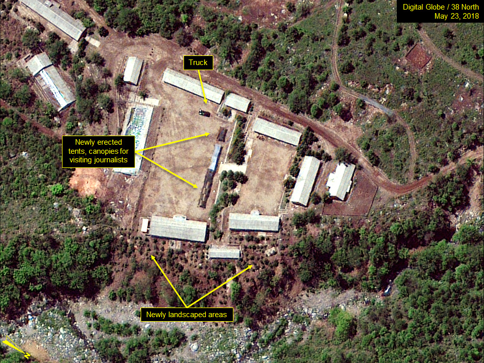
Main Administrative Support Area
Imagery from May 23 and prior to the demolition of the area the next day shows a new line of tents and covered canopies in the lower courtyard, which most likely served as a welcoming venue. The pallets and crates previously noted were likely associated with those tents/canopies. Several minor support buildings had been removed, primarily behind what are likely to be onsite personnel dining halls, replaced by a significant landscaping effort involving the planting of dozens of small trees or bushes.
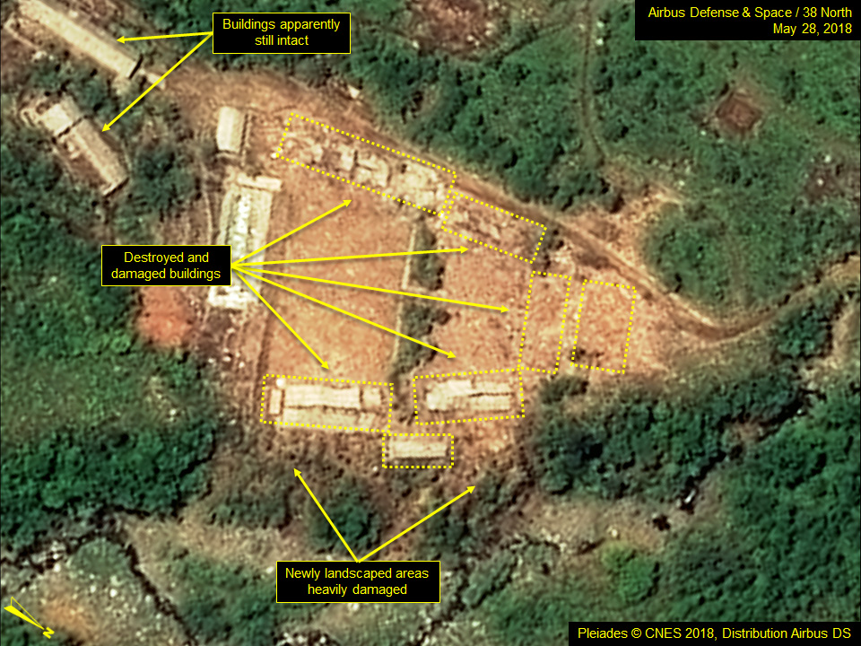
Although all of the buildings comprising the Main Administration Area were destroyed on May 24, satellite imagery from May 28 shows that a number of other buildings located between the Main Administration Area and the South Portal Area remain, including one which was built only in the past year. (Figure 5)
Figure 5. Main Administration Area before and after dismantlement.
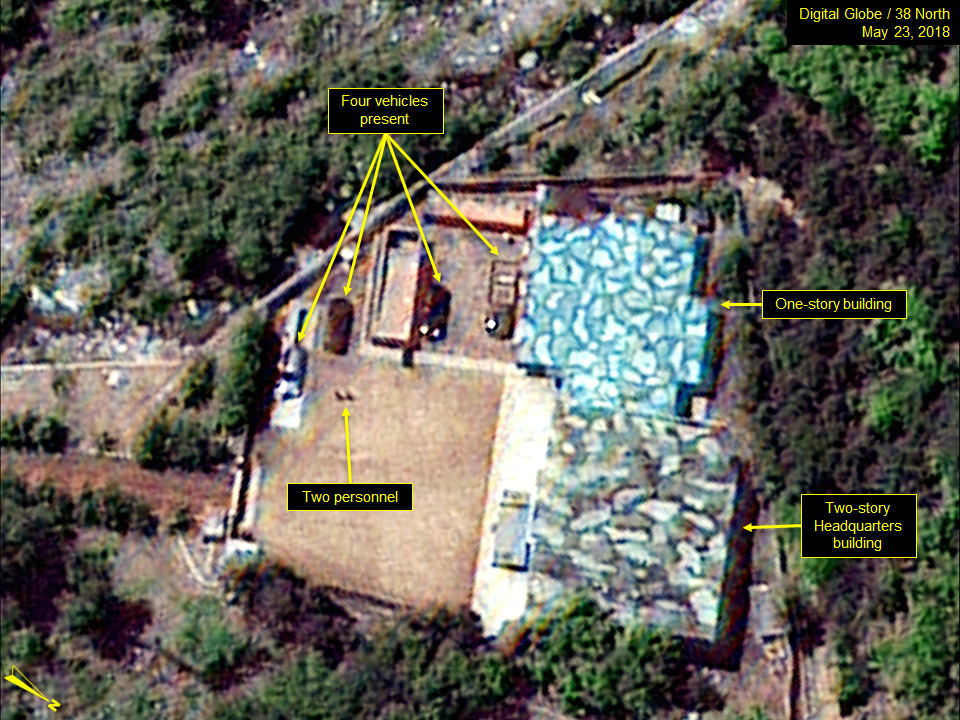
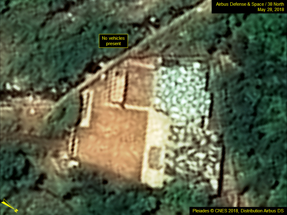
Command Center Compound and Surrounding Areas
The two main buildings at the Command Center, a two-story Headquarters Building and a one-story building adjacent to it remain intact. The four vehicles previously parked in the Command Center courtyard on May 23 were no longer present on May 28. (Figure 6)
Figure 6. Command Center remains intact despite site dismantlement.
Other support and barracks type buildings in the Command Center Support Area, the guard barracks nearby the security checkpoint located on the main access road to the Portals Area and the Southern Support Area were all still intact as of May 28.
Large Scale Topographic Map of the Tunnels Area Yields New Insights, but Raises Important New Question
When visiting journalists were briefed on the dismantlement of the Punggye-ri nuclear test site on May 24, the North Koreans displayed a large scale topographic map of the Northern Sector of the test site showing the areas that were about to be demolished. The annotated map also provided details on the tunnel entrance locations, the trajectory of tunnel excavations, along with what was purported to be the layout of the two tunnels at the East and North Portals used to conduct North Korea’s six acknowledged underground nuclear tests. It also showed the two other tunnels prepared for, but never employed in, nuclear testing at the South and West Portals. (Figure 7)
In addition, the map displayed the geospatial locations of the epicenters for each test, which had never before been revealed. Those geospatial locations compared favorably, varying from only a few tens of meters to no more than about 500 meters, with those independently derived by various researchers using relative seismic location analysis together with satellite based synthetic aperture radar data and commercial satellite electro-optical imagery.[1] (Figure 8)
Figure 7. Declared epicenters of North Korea’s six underground nuclear tests.
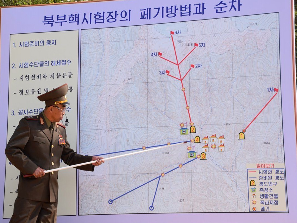
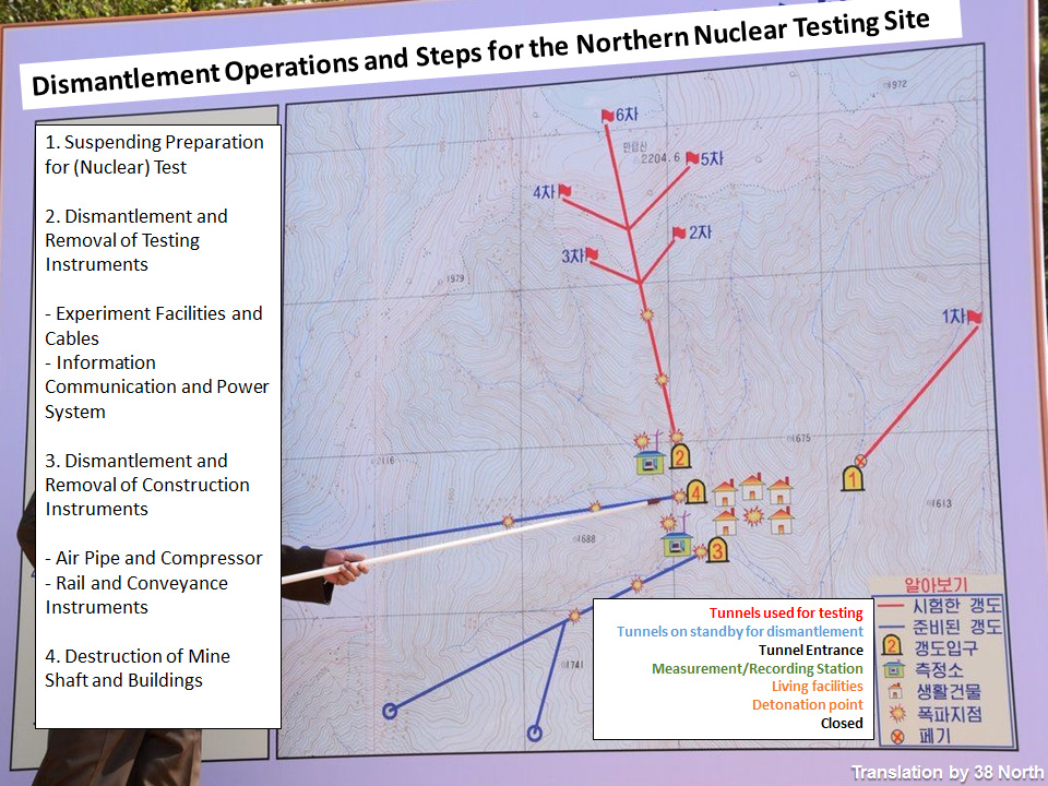
Figure 8. Estimated epicenters of North Korea’s six underground nuclear tests by outside experts.
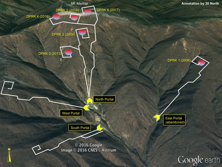
The locations for all five tests involving the North Portal progressed sequentially up the mountain, culminating with the 2017 test located directly under the peak of Mt. Mantap as had been generally supposed. Apart from the lack of engineered containment features (e.g., zig-zags or a fish-hook terminus at the end of each drift) shown in Figure 8, the general trajectories of all four of the tunnel systems also seem to match well with those previously conjectured by 38 North and other outside observers. The progression towards greater depth of burial (amount of rock above the test point) of the last five tests conducted via the North Portal also matches our previously published cross-section diagram. (Figure 9)
Figure 9. Cross-section diagram of the North Portal and Mt. Mantap.
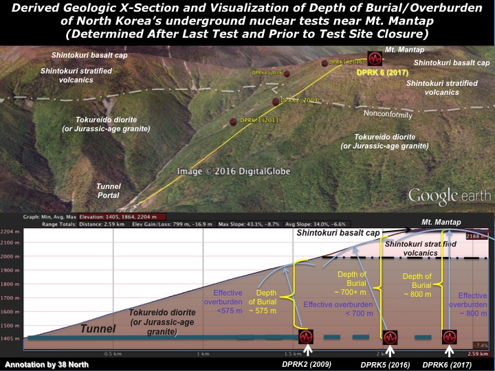
It is also significant to note that our cross-section diagram shows that the depth of burial under Mt. Mantap is about 800 meters. We had previously calculated that such a depth could successfully contain a test having a yield just above one quarter of a megaton. However, that 800 meter depth is at complete odds with a recent peer reviewed Science journal article that estimated the explosive source to be only “450 ± 100 m below the top of Mt. Mantap.” Given that the authors’ estimated epicenter depth was used in their 3D seismic modeling to explain the detected rise, collapse and compaction of Mt. Mantap, such a large discrepancy should be taken into consideration when reviewing the findings presented in that paper.
The incomplete data provided by the North Koreans, however, raises a critical question that goes to the issue of how irreversible the destruction of the test site really is. Why is the accumulated spoil outside of the North Portal since 2013 so much greater in volume when compared to that in front of the West Portal, when the West Portal is claimed to be ~2500 meters deep, while the tunnel sections involved in tests since 2013 amount to only ~2000 meters total according to the DPRK map? While measuring spoil piles is a commonly used tool to determine the scope of underground facilities, it is not fool proof. Nevertheless, it is possible, based on available data, that more tunneling took place under Mt. Mantap than the North Koreans have admitted thus far. “It should also be noted that at no time were the questions ever addressed regarding the detected prompt radiation leak from the first test in 2006, and the delayed radionuclide release from the third test in 2013. Moreover, no environmental sampling was undertaken, and visiting journalists were prevented from carrying portable radiation detectors before traveling to the test site.
- [1]
Frank V. Pabian, “The Punggye-ri Nuclear Test Site: A Test Tunnel Tutorial,” 38 North, May 23, 2018, https://www.38north.org/2018/05/punggyetunnel052318/; and T. Wang et al., Science
10.1126/science.aar7230 (2018) http://science.sciencemag.org/content/early/2018/05/09/science.aar7230.