More Underground Facilities Near Yongbyon: A Potential Challenge for Future Denuclearization Deals
Commercial satellite imagery reveals a previously publicly unidentified underground facility (UGF) beneath a hill in Bungang, the worker’s district adjacent to the Yongbyon Nuclear Scientific Research Center. Initial excavations of a 10-meter-wide tunnel into the side of the hill began in 2004, adjacent to a walled compound, along with a second excavation site within the compound. When tunnel excavations were completed in 2006, three small structures at the second site had also been erected, suggesting a moderately sized underground facility built beneath the hill.
The tunnel appeared to remain open until 2013, when its entrance was blocked, and the access road was subsequently fenced off from the main road. The small structures within the walled compound were also removed. Activity in and around the area of interest has been light since 2013, with the exception of terracing the side of the hill where the external structures were located in 2015.
The purpose of the underground facility remains unknown. Underground structures in residential areas are not unusual and may be used for storage, civil defense or other innocuous purposes. While there is no evidence that it is related to the North Korean nuclear program, the site’s proximity may raise suspicions. Moreover, there is reason to believe there may be other underground sites in the area that may also provoke the same concerns. Therefore, any future denuclearization agreements covering the Yongbyon nuclear facility may need to take this site and any others discovered nearby into consideration when formulating verification provisions.
Introduction
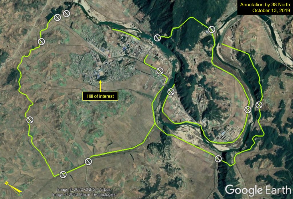
The Yongbyon Nuclear Scientific Research Center sits at the heart of a Cold War-style closed city that occupies 24.8 square kilometers and has several checkpoints into the city. It is split into two primary sections, the nuclear research section and the residential “workers district” (which also goes by the name of Bungang or Pun’gangni), although separated by fences and a guard post.
Figure 1. Overview of Yongbyon Nuclear Scientific Research Center’s perimeter and checkpoints.
North Korea has scores of underground facilities across its territory and hundreds more smaller tunnel systems used for various purposes. As such, rumors of underground sites existing at Yongbyon have persisted for decades. One of these UGFs was observed in 1992 by the International Atomic Energy Agency. Unconfirmed reports have suggested that there may be more in the vicinity. Subsequent research, including that from 38 North, has revealed the existence of additional underground sites within the nuclear research area and in Bungang as well, where a physics university is also said to exist.
New Discovery
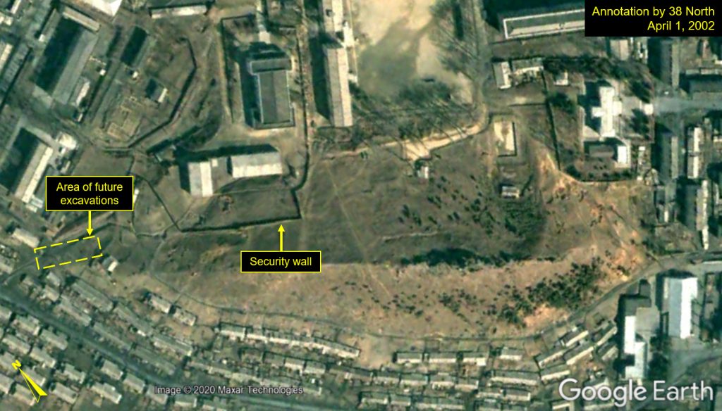
Commercial satellite imagery from 2002 of the area shows a low-lying hill near the center of Bungang, surrounded by houses and other buildings. At that time, there were no indications of an underground facility in that area.
Figure 2. Close-up of low-lying hill in Bungang, April 1, 2002.
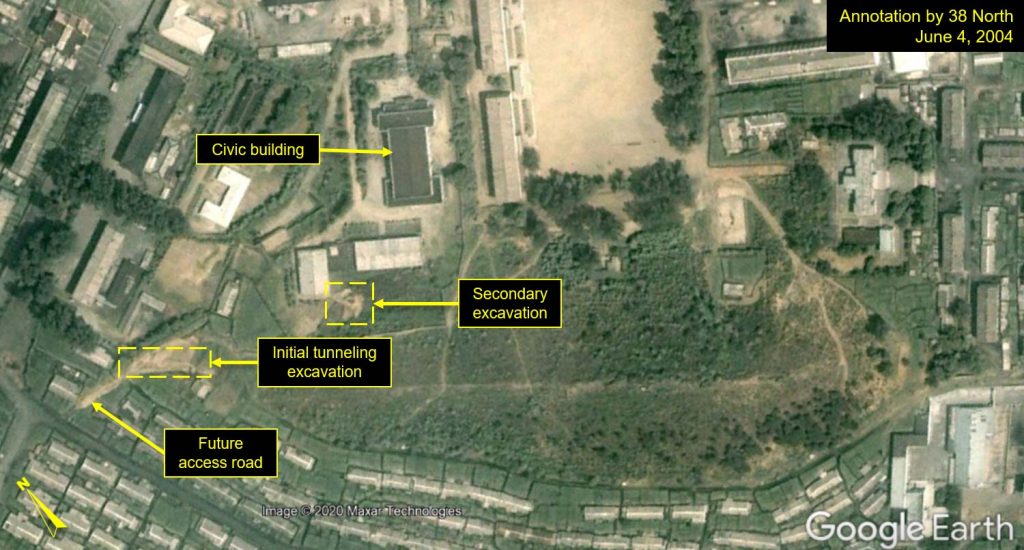
However, imagery from March 1, 2004, reveals initial excavation work of a tunnel at the western edge of the hill, adjacent to a walled compound, with more obvious signs of excavation observed on June 4, 2004. Around the same time, a second excavation site is also observed within the walled compound.
This hill is not an obvious location for building a secret underground facility, as it is small and only rises about 24 meters above the surrounding area.
Figure 3. Initial tunnel excavation work observed, June 4, 2004.
It is on the eastern end of an intrusive vein of ancient magmatic rock that rises above the surface in six places, forming a range of six low hills that runs north-northwest for nearly 4.7 km.
While this part of North Korea is covered in fault lines, very few are active, and this is one of the most seismically stable regions between South Korea and China. Thus, given its geologic nature, this area is suitable for underground facilities as the hills and nearby mountains are stable enough to allow for a range of design configurations within them.
Construction initially moved at a slow pace. It took two years before the 10-meter wide tunnel entrance was completed. At the same time, from 2004 to 2006 and approximately 97-100 meters to the east, additional excavation activities took place behind an L-shaped building. They advanced quickly in 2006, with three small structures being erected by the end of the year and protruding out from the hillside at the location of the second excavation site. These two excavation projects together suggest a moderately sized underground facility was built beneath the hill.
The purpose of the UGF is unknown and little can be identified in the available imagery about the facility’s infrastructure. However, no electrical lines feeding into the site have been observed, suggesting that the UGF’s electricity demand fits within the local area’s current capacity. Additionally, no external ventilation systems are visible, although ventilation could be provided from air intakes at the tunnel entrance. In the absence of these types of indicators, it is difficult to tell if this facility serves a civilian purpose, such as storage or civil defense, or whether it may be related to the North’s nuclear program, given its proximity to the Yongbyon nuclear complex.
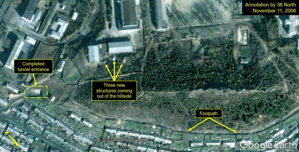
Figure 4. Completed tunnel entrance and additional excavation activities observed, November 11, 2006.
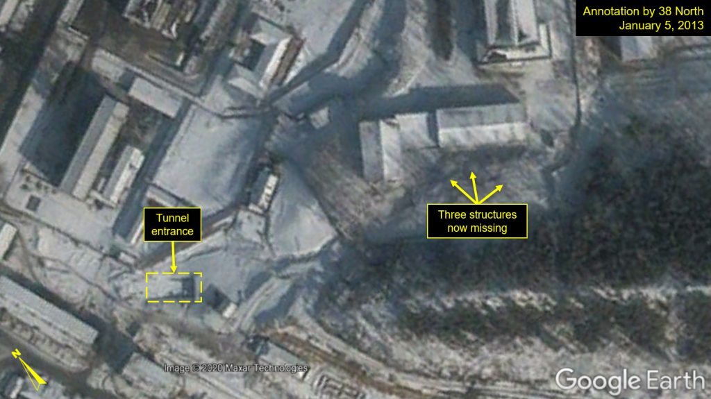
In several future images, the area is obscured by tree cover, making it difficult to track what may have been happening at these facilities after 2006. The entrance and access road remained open until April 2011 when authorities began to construct apartment buildings very near to the site. By 2011, the small, external structures had been removed, and from 2013 onward, there was little evidence of the access road and tunnel entrance being used.
Figure 5. Little evidence of access road or tunnel entrance usage, January 5, 2013.
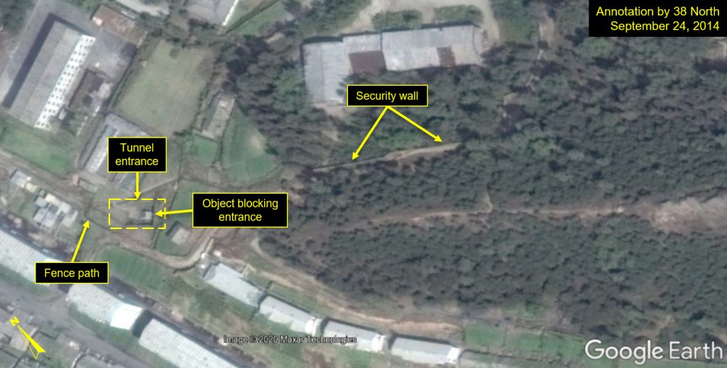
By late 2014, the access road had been fenced off and a rectangular object (or set of stone blocks) was placed near the entrance point, preventing future vehicle traffic into the tunnel; however, there is still room on either side of the block to allow foot traffic in and out.
Figure 6. Access road fenced off and entrance blocked, September 24, 2014.
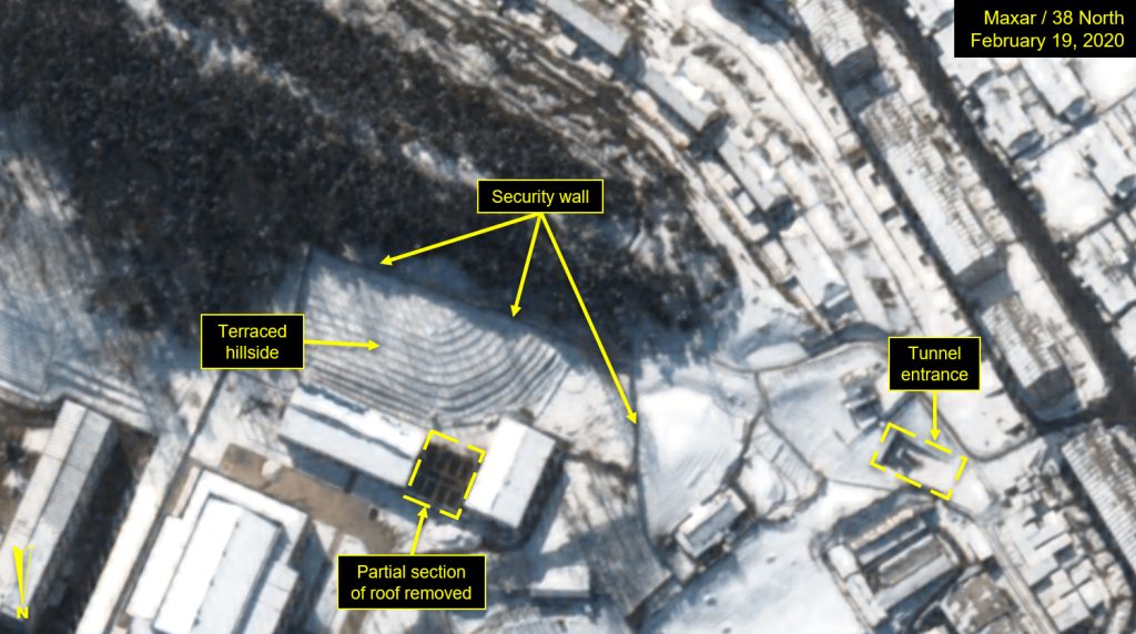
Imagery from February 19, 2020, shows undisturbed snow on the terraced hillside (which was terraced in 2015), at the original entrance (where the entrance block remains) and along the hillside, supporting the assessment that there is limited to no ongoing activity at or within the tunnel complex. However, there is activity at the above-ground buildings within the walled complex, and a partial section of roofing has been removed from the older L-shaped building.
Figure 7. Close-up of terraced hillside shows limited to no ongoing activity at or within tunnel complex, February 19, 2020.
Whether the underground site was meant to be temporary or whether it was deemed unsuitable for operations after it was constructed is unknown.
A suspected uranium enrichment facility around this location was reportedly discussed in US-DPRK nuclear negotiations in 2019, however, it is unlikely they were referring to this UGF, especially given the lack of activity around this site in the past few years.
Conclusion
Commercial satellite imagery can only provide a very limited understanding of the underground facility’s purpose, but its location in the greater Yongbyon area warrants further observation for indicators, such as power lines and ventilation configurations, to gain a clearer understanding of its purpose.
North Korea has taken great care to obscure and hide its activities at the Yongbyon Nuclear Scientific Research Center since its early days in the 1960s. Despite the international community’s best efforts to try to uncover and assess what exists in and around the complex, there is still a lot that remains unknown.