The North Korean Economy: Assessing the Flood Damage
In the late summer and early fall, as happens in most years, the DPRK was hit by massive flooding and other damage from heavy rains and typhoons.[1] Although North Korean media and humanitarian organizations have not published an overall assessment of the damage, some data suggest that cropland damage in the rice bowl provinces from the rainfall is not unprecedented, and in fact is lower this year than in previous years.[2]
The Magnitude of the Flooding
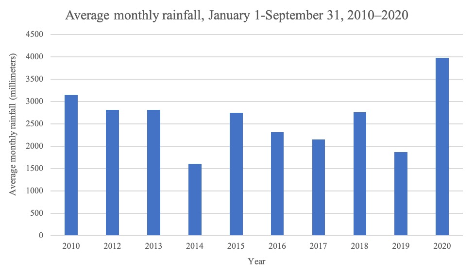
Although not a perfect metric, rainfall amounts provide a good sense of the magnitude of the flooding. The following graph shows that rainfall between January and September in 2020 was more than twice as great as in the same months in 2019.
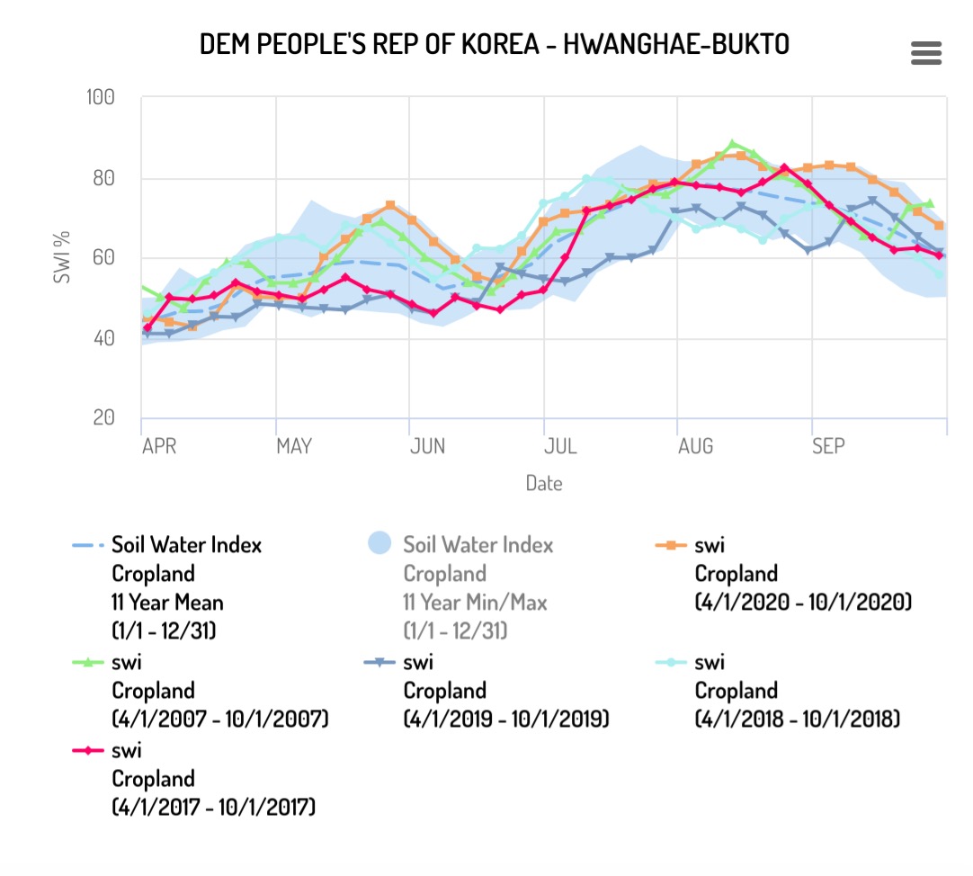
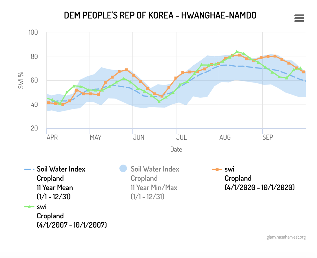
While the rains were heavy, however, they were not entirely unprecedented—in fact, in 2007 North Korea saw similar levels of rainfall. The following graph shows the soil water index (SWI), a measurement of the proportion of water absorbed in soil, for croplands in North Hwanghae province, one of North Korea’s main agricultural regions, over the past five years. When SWI is high, it can mean that the soil is inundated with water, and when it is low, it shows that the soil is dry. The graph shows that as a result of the summer rains, SWI was often at its highest points during the past ten years (the blue area shows the minimum and maximum levels for 2010–2020).
The following graph shows the same data for South Hwanghae Province, another crucial agricultural region.
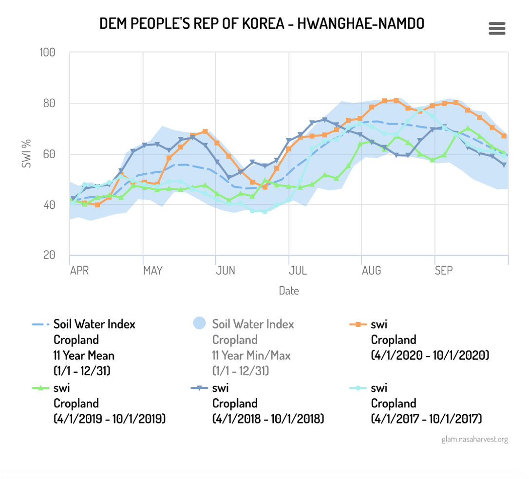
This graph again shows South Hwanghae province as an example, comparing the two years of 2007 and 2020:
Scattered News Reports Suggest Normal Damage
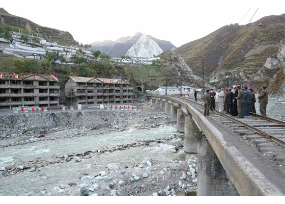
One of the most unusual features of this year’s flooding season was the extensive coverage from around the country—sometimes in real time—by North Korean media. In early September, the Korean Central News Agency (KCNA) reported that Typhoon Maysak left more than 2,000 homes and dozens of public buildings destroyed. State media has also reported damage to some thousand residential houses and public buildings in several localities. One such report came from South Hamgyong Province, referring to about ten cities and counties.[3] It also said that the situation in North Hamgyong Province was similar. Rodong Sinmun gave similar numbers for damage in Kimhwa County, reporting that several roads had been cut off;[4] one of the most comprehensive summaries of the damage came in a report in mid-August.[5] It stated that:
[d]uring the rainy season 39 296 hectares of crops were damaged nationwide including Kangwon, North and South Hwanghae Provinces and Kaesong City, at least 16 680 dwelling houses and over 630 public buildings were destroyed or inundated, lots of roads, bridges and railway sections broken, a dam of a power station gave way and there were other severe damage in various sectors of the national economy.
As far as 38 North has been able to ascertain, no assessment has yet been published of overall damage for the entire flooding season. Indeed, contacts in the humanitarian and diplomatic communities confirm that information has been sparse about these consequences, and media reports may not provide a comprehensive picture. While North Korean sources have emphasized the extensive scope of the destruction, the scattered numbers that state media has put out look relatively normal and do not suggest unprecedented levels of damage. In 2007, a particularly bad year of flooding, North Korean authorities reported that 223,381 hectares of cultivated lands were severely damaged.[6] In 2012, KCNA reported that 8,600 dwellings were destroyed, with 43,770 houses in North and South Pyongan and Hamgyong provinces submerged, making 212,200 people homeless.[7] And in 2016, KCNA reported that 560 public buildings had been destroyed in North Hamgyong province alone, with 7,980 hectares of paddy and dry fields submerged.[8]
Conclusion
North Korea is regularly hit by floods and typhoons. Pyongyang has improved its disaster management practices, but they are still woefully inadequate, and much of the flood damage is caused by the state’s failure to adequately plan and prepare for such events. It is difficult to make comparisons across years since the North Korean government rarely publishes any unified, coherent damage assessments. Nonetheless, while weather conditions were particularly dire this year, there is currently no evidence, based on currently available information, that the overall damage was unprecedented.
- [1]
The author is grateful to Christina Justice and James Banfill. All errors and opinions belong solely to the author.
- [2]
This picture may well change as more information becomes available. Moreover, it is important to bear in mind that the recent flooding hit North Korea at an already very difficult time with heavy sanctions and a border shutdown due to COVID-19.
- [3]
Kim Jong Un, “Supreme Leader Kim Jong Un Sent Open Letter to All Party Members in Pyongyang,” Rodong Sinmun, September 6, 2020.
- [4]
Political News Team, “Supreme Leader Kim Jong Un Inspects Sites of Reconstruction in Kimhwa County,” Rodong Sinmun, October 2, 2020.
- [5]
Political News Team, “16th Meeting of Political Bureau of 7th Central Committee of WPK Held,” Rodong Sinmun, August 14, 2020.
- [6]
GEOGLAM Crop Monitor, “Heavy rains and flooding in August affect primary rice
producing areas in the Democratic People’s Republic of Korea,” Special Report, August 13, 2020, updated September 9, 2020, accessed October 16, 2020, https://cropmonitor.org/documents/SPECIAL/reports/Special_Report_20200901_DPRK_Flooding.pdf. - [7]
“DPRK Suffers Damage from Flood,” KCNA, August 4, 2012.
- [8]
“DPRK Focuses on Flood Damage Rehabilitation,” KCNA, September 6, 2016.